Sa Kaeo
|
สระแก้ว Sa Kaeo |
||
|---|---|---|
|
|
||
| Coordinates | 13 ° 49 '14 " N , 102 ° 3' 32" E | |
| Symbols | ||
|
||
| Basic data | ||
| Country | Thailand | |
| Sa Kaeo | ||
| ISO 3166-2 | TH-27 | |
| surface | 17 km² | |
| Residents | 71,200 (2000) | |
| density | 4,200.6 Ew. / km² | |
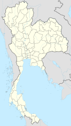
Sa Kaeo ( Thai สระแก้ว ) is the capital of the district ( Amphoe ) Mueang Sa Kaeo and the province Sa Kaeo . Sa Kaeo Province is located in the east of the central region of Thailand .
geography
Sa Kaeo is located on the eastern edge of the central region and is about 220 kilometers from the capital Bangkok . The Pang Sida National Park (Thai: อุทยานแห่งชาติ ปาง สี ดา ) is located in the forested mountains on the border between the provinces of Sa Kaeo and Prachin Buri .
history
Sa Kaeo has only been the capital of the province that was separated from the province of Prachin Buri since 1993 .
Economy and Importance
Sa Kaeo is a center of trade with Cambodia , which is transacted through the border town of Aranyaprathet .
Attractions
- Sakaeo - Sakhwan (Thai: สระแก้ว สระ ขวัญ ) - two ponds bordered with stone walls just outside the city, the water of which is considered sacred. It was used earlier in the coronation ceremony.
Personalities
- Kanok Kohyangphueak (* 1989), football player
Web links
- City map of Sa Kaeo (names in English and Thai) [last accessed on October 21, 2013]

