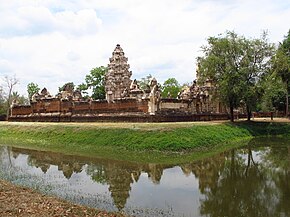
Aranyaprathet district
|
Aranyaprathet อรัญประเทศ |
|
|---|---|
| Province: | Sa Kaeo |
| Surface: | 821.3 km² |
| Residents: | 85,755 (2013) |
| Population density : | 89.9 U / km² |
| ZIP : | 27120 |
| Geocode : | 2706 |
| map | |

|
|
Amphoe Aranyaprathet ( Thai : อำเภอ อรัญประเทศ ) is a district ( amphoe - administrative district) in the province of Sa Kaeo . The province of Sa Kaeo is located in the eastern region of Thailand on the border with Cambodia , but is administratively counted to central Thailand .
geography
Amphoe Aranyaprathet is bounded by the following Amphoe (clockwise as seen from the southwest): Khlong Hat , Watthana Nakhon and Khok Sung in Sa Kaeo Province. In the south-east lies the land border with Cambodia .
history
Aranyaprathet was originally part of Kabin Buri Province. On April 1, 1926, the province was dissolved, the two districts of Mueang Kabin Buri and Aranyapathret were assigned to the province of Prachin Buri . In 1993, Aranyaprathet was separated from Prachin Buri to become part of the newly established Sa Kaeo Province.
refugees
Between 1979 and the mid-1980s, the Aranyaprathet region was home to around 300,000 Cambodian refugees who fled to Thailand amid the invasion of Vietnamese troops and the threat of famine in Cambodia. Among them was Site 8 , the largest camp of supporters of the disempowered Khmer Rouge with over 30,000 inmates at times. It was closed in 1993 after the refugees had been repatriated to the now largely pacified Cambodia.
At that time, the refugees were supplied by international aid organizations. The beneficiaries of the aid were also the Khmer Rouge troops who fled Cambodia to Thailand, who regrouped in the border region and carried out military attacks against the Vietnamese troops within Cambodia. The aid shipments for the Cambodian refugees were controlled by the Thai military , which observers believe to have enriched itself not insignificantly in this context.
Border crossing
Tourists who want to travel overland from Thailand to Siem Reap ( Angkor ) and on to Phnom Penh use the Aranyaprathet border crossing. Thais often travel to Aranyaprathet to try their luck at Poipet 's gambling casinos across the border .
administration
Provincial Administration
The district of Aranyaprathet is divided into 13 tambon ("sub-districts" or "municipalities"), which are further subdivided into 114 muban ("villages").
| No. | Surname | Thai | Muban | Pop. |
|---|---|---|---|---|
| 1. | Aranyaprathet | อรัญประเทศ | - | 16.309 |
| 2. | Mueang Phai | เมือง ไผ่ | 8th | 4,296 |
| 3. | Han Sai | หัน ทราย | 10 | 5,602 |
| 4th | Khlong Nam Sai | คลอง น้ำ ใส | 12 | 5,426 |
| 5. | Tha Kham | ท่า ข้าม | 11 | 4,783 |
| 6th | Pa Rai | ป่า ไร่ | 9 | 6.240 |
| 7th | Thap Phrik | ทับ พริก | 7th | 3,629 |
| 8th. | Ban Mai Nong Sai | บ้าน ใหม่ หนอง ไทร | 8th | 9,582 |
| 9. | Phan Suek | ผ่าน ศึก | 13 | 6,588 |
| 10. | Nong Sang | หนอง สังข์ | 8th | 6,953 |
| 11. | Khlong Thap Chan | คลอง ทับ จันทร์ | 10 | 4,681 |
| 12. | Fak Huai | ฟาก ห้วย | 11 | 6,894 |
| 13. | Ban Dan | บ้าน ด่าน | 7th | 4,772 |
Local administration
There is one commune with "city" status ( Thesaban Mueang ) in the district:
- Aranyaprathet (Thai: เทศบาล เมือง อรัญ ญ ประเทศ ) consisting of the complete tambon Aranyaprathet.
There are four municipalities with "small town" status ( Thesaban Tambon ) in the district:
- Pa Rai (Thai: เทศบาล ตำบล ป่า ไร่ ) consisting of the complete tambon Pa Rai.
- Ban Mai Nong Sai (Thai: เทศบาล ตำบล บ้าน ใหม่ หนอง ไทร ) consisting of the complete tambon Ban Mai Nong Sai.
- Fak Huai (Thai: เทศบาล ตำบล ฟาก ห้วย ) consisting of the complete tambon Fak Huai.
- Ban Dan (Thai: เทศบาล ตำบล บ้าน ด่าน ) consisting of the complete tambon Ban Dan.
In addition, there are eight " tambon administration organizations " ( องค์การ บริหาร ส่วน ตำบล - Tambon Administrative Organizations, TAO)
- Mueang Phai (Thai: องค์การ บริหาร ส่วน ตำบล เมือง ไผ่ ) consisting of the complete tambon Mueang Phai.
- Han Sai (Thai: องค์การ บริหาร ส่วน ตำบล หัน ทราย ) consisting of the complete Tambon Han Sai.
- Khlong Nam Sai (Thai: องค์การ บริหาร ส่วน ตำบล คลอง น้ำ ใส ) consisting of the complete tambon Khlong Nam Sai.
- Tha Kham (Thai: องค์การ บริหาร ส่วน ตำบล ท่า ข้าม ) consisting of the complete Tambon Tha Kham.
- Thap Phrik (Thai: องค์การ บริหาร ส่วน ตำบล ทับ พริก ) consisting of the complete tambon Thap Phrik.
- Phan Suek (Thai: องค์การ บริหาร ส่วน ตำบล ผ่าน ศึก ) consisting of the complete tambon Phan Suek.
- Nong Sang (Thai: องค์การ บริหาร ส่วน ตำบล หนอง สังข์ ) consisting of the complete Tambon Nong Sang.
- Khlong Thap Chan (Thai: องค์การ บริหาร ส่วน ตำบล คลอง ทับ จันทร์ ) consisting of the complete tambon Khlong Thap Chan.
Individual evidence
- ↑ ประกาศ เรื่อง ยุบ จังหวัด กบินทร์บุรี ลง เป็น อำเภอ ขึ้น จังหวัด ปราจีน . In: Royal Gazette . 42, No. 0 ก , March 31 1926, pp. 430-431.
- ^ International Committee of the Red Cross: Annual Report. 1993, p. 125.
- ↑ 2013 population statistics ( Thai ) Department of Provincial Administration. Retrieved October 22, 2014.
Web links
Coordinates: 13 ° 42 ' N , 102 ° 31' E

