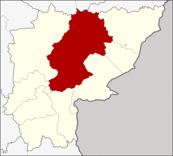
Watthana Nakhon district
|
Watthana Nakhon วัฒนานคร |
|
|---|---|
| Province: | Sa Kaeo |
| Surface: | 1560.12 km² |
| Residents: | 80,610 (2013) |
| Population density : | 51.1 U / km² |
| ZIP : | 27160 |
| Geocode : | 2705 |
| map | |

|
|
Amphoe Watthana Nakhon ( Thai : อำเภอ วัฒนานคร ) is a district ( amphoe - administrative district) in the province of Sa Kaeo . The province of Sa Kaeo is located in the eastern region of Thailand on the border with Cambodia , but is administratively counted to central Thailand .
geography
Neighboring districts (clockwise from east): Amphoe Ta Phraya , Khok Sung , Aranyaprathet , Khlong Hat , Wang Nam Yen , Khao Chakan , Mueang Sa Kaeo of Sa Kaeo Province, Amphoe Khon Buri and Soeng Sang of Nakhon Ratchasima Province and Amphoe Non Din Daeng of Buriram Province .
history
Watthana Nakhon is an ancient city. Before 1917 Watthana, as it was originally called, was established as a "branch circle" ( King Amphoe ) of Amphoe Aranyaprathet before it was promoted to Amphoe Watthana Nakhon on June 6, 1956.
education
The Sa Kaeo campus of Burapha University is located in the Watthana Nakhon district .
administration
Provincial Administration
Watthana Nakhon County is divided into eleven tambon ("subdistricts" or "parishes"), which are further subdivided into 115 muban ("villages").
| No. | Surname | Thai | Muban | Pop. |
|---|---|---|---|---|
| 1. | Watthana Nakhon | วัฒนานคร | 14th | 13,393 |
| 2. | Tha Kwian | ท่า เกวียน | 14th | 10,440 |
| 3. | Phak Kha | ผัก ขะ | 13 | 5,343 |
| 4th | Non Mak Kheng | โนน หมาก เค็ ง | 9 | 5,394 |
| 5. | Nong Nam Sai | หนอง น้ำ ใส | 10 | 6,763 |
| 6th | Chong Kum | ช่อง กุ่ม | 9 | 5,881 |
| 7th | Nong Waeng | หนอง แวง | 7th | 3,770 |
| 8th. | Sae-o | แซ ร์ ออ | 14th | 10,837 |
| 9. | Nong Mak Fai | หนอง หมาก ฝ้าย | 8th | 6,036 |
| 10. | Nong Takhian Bon | หนอง ตะเคียน บอน | 10 | 6,529 |
| 11. | Huai Chot | ห้วย โจ ด | 7th | 6.224 |
Local administration
There is one municipality with "small town" status ( Thesaban Tambon ) in the district:
- Watthana Nakhon (Thai: เทศบาล ตำบล วัฒนานคร ) consisting of parts of the Tambon Watthana Nakhon.
In addition, there are eleven " tambon administration organizations " ( องค์การ บริหาร ส่วน ตำบล - Tambon Administrative Organizations, TAO)
- Watthana Nakhon (Thai: องค์การ บริหาร ส่วน ตำบล วัฒนานคร ) consisting of parts of the Tambon Watthana Nakhon.
- Tha Kwian (Thai: องค์การ บริหาร ส่วน ตำบล ท่า เกวียน ) consisting of the complete Tambon Tha Kwian.
- Phak Kha (Thai: องค์การ บริหาร ส่วน ตำบล ผัก ขะ ) consisting of the complete tambon Phak Kha.
- Non Mak Kheng (Thai: องค์การ บริหาร ส่วน ตำบล โนน หมาก เค็ ง ) consisting of the complete tambon Non Mak Kheng.
- Nong Nam Sai (Thai: องค์การ บริหาร ส่วน ตำบล หนอง น้ำ ใส ) consisting of the complete tambon Nong Nam Sai.
- Chong Kum (Thai: องค์การ บริหาร ส่วน ตำบล ช่อง กุ่ม ) consisting of the complete Tambon Chong Kum.
- Nong Waeng (Thai: องค์การ บริหาร ส่วน ตำบล หนอง แวง ) consisting of the complete Tambon Nong Waeng.
- Sae-o (Thai: องค์การ บริหาร ส่วน ตำบล แซ ร์ ออ ) consisting of the complete tambon Sae-o.
- Nong Mak Fai (Thai: องค์การ บริหาร ส่วน ตำบล หนอง หมาก ฝ้าย ) consisting of the complete tambon Nong Mak Fai.
- Nong Takhian Bon (Thai: องค์การ บริหาร ส่วน ตำบล หนอง ตะเคียน บอน ) consisting of the complete Tambon Nong Takhian Bon.
- Huai Chot (Thai: องค์การ บริหาร ส่วน ตำบล ห้วย โจ ด ) consisting of the complete tambon Huai Chot.
Individual evidence
- ↑ พระราชกฤษฎีกา จัดตั้ง อำเภอ นาทวี อำเภอ สะบ้าย้อย อำเภอ คำชะอี อำเภอ ย่านตาขาว อำเภอ วัดโบสถ์ อำเภอ หนองบัว อำเภอ วัฒนานคร อำเภอ แสวงหา อำเภอ ท่าชนะ อำเภอ พระพุทธบาท อำเภอ โนนสัง อำเภอ อำเภอ บำเหน็จณรงค์ อำเภอ คอนสวรรค์ อำเภอ บ้านโฮ่ง บ้านโฮ่ง อำเภอ คีรีมาศ อำเภอ ชนแดน อำเภอ แม่แจ่ม อำเภอ ไทรน้อย และ อำเภอ บ้านแพง พ.ศ. ๒๔๙๙ . In: Royal Gazette . 73, No. 46 ก , June 5, 1956, p. 657.
- ↑ 2013 population statistics ( Thai ) Department of Provincial Administration. Retrieved October 22, 2014.
Web links
Coordinates: 13 ° 45 ' N , 102 ° 18' E