Sacbé

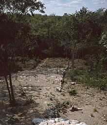
Sacbé ("white way", from Mayathan : sac = "white", bé = "way"; plural Sacbeob ) denotes a Maya road that connected ceremonial buildings within a settlement or nearby cities. The name arose from the way the street was built, which was massively piled up and covered with white stucco or lime.
Construction
According to their construction, Sacbeob are actually only very long, narrow places. In general, the Sacbeob are about five to ten meters wide. When they were built, the walls that were supposed to represent the boundary were first put in place and then the space in between was filled with rubble. As with the plastered squares and courtyards, a layer of small stones (2 to 5 cm in diameter) was first placed on top of this layer of rubble. A slightly curved layer of lime mortar was then placed on top of this to protect the road from rainwater and a high degree of wear and tear. The height above the terrain depends on its shape and can be up to several meters to cross depressions. Usually, however, there are only more simple rows of stones as a lateral boundary. Thanks to their construction, many of the Sacbeob can still be seen in the terrain, even if they can no longer be used as roads. The streets were often broken up by small platforms and stairs.
The most important supra-local Sacbeob in Yucatán
| from | to | over | length | Specialty |
| Uxmal | Kabah | Nohpat | 18 km | low |
| Yaxuná | Cobá | over 100 km | laborious | |
| Izamal | Aké | 30 km | medium high | |
| Izamal | Kantunil | 14 km | low | |
| Uci | Cansahcab | 17 km | medium high |
The extension of the Sacbe from Izamal west to Mérida and east to the Caribbean coast near Puerto Morelos is largely hypothetical. A sacbé between Calakmul and El Mirador over 50 km is now considered secured.
function
The function of the supra-local Sacbeob is largely in the dark. Since wagons and the necessary draft animals were not available, it cannot be used for the transport of goods. They had more of a symbolic political meaning in that they emphasized the connection between two cities. The Sacbeob that led to Izamal were probably used as processional routes to the great and important shrines of Izamal. Supra-local Sacbeob were also found in Peten in northern Guatemala near El Mirador .
Inner-city Sacbeob can be found in large numbers , especially in Cobá and Chichén Itzá , where they led from the center to various settlements and ceremonial buildings outside. Here it is sometimes difficult to differentiate between local and regional Sacbeob.
literature
- Markus Eberl: Processions, pilgrims, porters - the ceremonial streets . In: Nikolai Grube (Hrsg.): Maya - God Kings in the Rainforest . Könemann-Verlag, Cologne 2000, ISBN 3-8290-1564-X , p. 232f.
Web links
- Yucatan Sacbés (English)
Individual evidence
- ↑ Alina Schadwinkel: On the White Path of Power. on Spektrum.de from February 25, 2020.
- ↑ Jennifer Mathews: The long and windig road: regional Maya sacbe, Yucatán Península, México . http://www.famsi.org/reports/98027/98027Mathews01.pdf


