
Saddle Mountains
| Saddle Mountains | |
|---|---|
| Highest peak | Wahatis Peak ( 803 m ) |
| location | Grant County , Washington , USA |
| Coordinates | 46 ° 48 ′ N , 119 ° 33 ′ W |
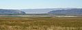
 The Saddle Mountains from the south in summer 2006. A gas drilling rig in the center of the picture. |
|
The Saddle Mountains consist of an unfolded anticline basalt ridge in Grant County in the central part of the US state Washington . The main ridge reaches a maximum height of 803 meters and ends in the east south of Othello near the foot of the Drumheller Channels . It continues west, where it is interrupted by the Sentinel Gap (a gap through which the Columbia River flows) before ending in the foothills of the Cascade Range .
geology
The top layer of the Columbia River Basalt Group in the Saddle Mountains is the Saddle Mountain Basalt, which is between 120 and 240 meters thick and criss-crossed by sediment layers from the Ellensburg Formation. The Saddle Mountain Basalt consists of the following basalt rivers:
- 13 million years old
- Umatilla member
- Wilbur Creek Member
- Asotin member
- 10.5 million years old
- Weissenfels Ridge Member
- Esquatzel member
- Elephant Mountain Member
- 8.5 million years old
- Bujford member
- Ice Harbor Member
- 6 million years old
- Lower Monumental Member
The Cordilleras Ice Sheet divided the prehistoric course of the Columbia River about 15,000 years ago and dammed the water to Lake Spokane. As the Okanogan rag grew, the Columbia was diverted to the Grand Coulee . By flowing through what is now the Grand Coulee- Dry Falls region , Ice Age Columbia reached the Quincy Basin and merged with Crab Creek in Moses Lake, followed the course of Crab Creek southwards below the Frenchman Hills, and turned west to along the North side of the Saddle Mountains continues to flow. There it united with the former and present course of the Columbia River just above the main breakthrough in the Saddle Mountains, the Sentinel Gap. It eroded the north side of the Saddle Mountains, creating the conditions for the Corfu Slide .
geography
![]() Map with all coordinates of the geography section : OSM
Map with all coordinates of the geography section : OSM
| place | Coordinates |
|---|---|
| Eastern part of the Saddle Mountains where the lower Crab Creek meets the Corfu Slide |
46 ° 49 ′ N , 119 ° 23 ′ W. |
| Territory of the Red Rock Coulee | 46 ° 49 ' N , 119 ° 35' W |
| Sentinel Gap with the breakthrough of the Columbia River | 46 ° 49 ' N , 119 ° 54' W |
| Region of the Corfu Slide in the Saddle Mountains | 46 ° 48 ' N , 119 ° 35' W. |

The Saddle Mountains: View from the main ridge to the east into the Wahluke Wildlife Refuge (spring 2007)
The "Sentinel Gap" in the Saddle Mountains from the north
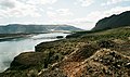
The "Sentinel Gap" on the west bank of the Columbia River above the Wanapum Dam

The Saddle Mountains from the John Wayne Pioneer Trail looking southeast towards the Boylston Tunnel


See also
Individual evidence
- ^ Robert J. Carson, Kevin R. Pogue: Flood Basalts and Glacier Floods: Roadside Geology of Parts of Walla Walla, Franklin, and Columbia Counties, Washington . Washington State Department of Natural Resources (Washington Division of Geology and Earth Resources Information Circular 90), 1996.
- ↑ Bruce Bjornstad: On the Trail of the Ice Age Floods: A Geological Guide to the Mid-Columbif Basin . Keokee Books; San Point, Idaho, 2006, ISBN 978-1-879628-27-4 .
- ^ J Harlen Bretz: The Channeled Scabland of the Columbia Plateau . In: Journal of Geology . 31, 1923, pp. 617-649.
- ↑ Ted and Marge Mueller: Fire, Faults & Floods . University of Idaho Press, Moscow, Idaho, 1997, ISBN 0-89301-206-8 .