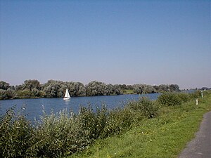
Salzgittersee
| Salzgittersee | ||
|---|---|---|

|
||
| Salzgittersee, September 2005 | ||
| Geographical location | Salzgitter - Lebenstedt , Lower Saxony | |
| Places on the shore | Salzgitter-Lebenstedt | |
| Data | ||
| Coordinates | 52 ° 9 '25 " N , 10 ° 18' 18" E | |
|
|
||
| Altitude above sea level | 81.3 to 82.8 | |
| surface | 75 ha | |
| length | 2.12 km | |
| width | 800 m | |
| volume | 1,875,000 m³ | |
| Maximum depth | 17 m | |
| Middle deep | 2.5 m | |
|
particularities |
Quarry pond |
|
The Salzgittersee is a 2.1 km long and 0.8 km wide lake in the west of the Salzgitteran district of Lebenstedt , Lower Saxony . In the 75 hectare man-made lake there is a 25 hectare island which can be reached via a bridge.
history
Emergence
The first considerations for creating a recreational area in the lowlands of the small rivers Fuhse and Flote (also Flothe , a tributary of the Fuhse) date back to the mid-1930s, but it was not until 1958 that the first concrete plans were made and in 1959 the surveying of the Fuhse valley began . To enable the financing of the project, the company Steine und Erden GmbH (later FELS-Werke , a company of the then Salzgitter AG ) was entrusted with the economic exploitation of the gravel deposits in the future area of the lake. On the west side of the lake, a gravel and concrete works were built in which the dredged gravel was processed. The gravel extraction , which at the end was only operated on the north bank, was finally stopped in 1976.
The groundbreaking ceremony to start dredging work took place on October 5, 1960. As early as May 27, 1963, a part of the lake, which was 34 hectares in size, was released for swimming and water sports. In the years that followed, the planned size of the lake was steadily expanded; in 1967, a water area of 42 hectares was expected, in 1968 it was 50 hectares and an area of 75 hectares was specified as the final planning target since April 1972. Between 1964 and 1971, the Fuhse was relocated to the west in two steps so that it no longer flowed through the lake. This means that the lake has no above-ground inflow and is only fed by a strong groundwater flow (16 l / s), which runs parallel to the float in the gravelly subsoil.
The 25-hectare island that was heaped up during the dredging of the lake was connected to the western shore by a pylon bridge in 1974 . In 1976/77 an ice rink was built near the bridge. A total of 20 hectares were created around the Salzgittersee for playing, recreational activities and recreation.
Further development
Work is currently underway on the further development of the Salzgittersee. In 2015, a new building with a café was opened in the north of the Salzgittersee in the Reppner Bay.
According to the decision of the Salzgitter City Council in 2016, the lake on the east bank is to be given a promenade. In addition, participation processes took place with the citizens in 2018 and 2019 in order to collect and plan further development opportunities around the lake.
Leisure business
The Salzgittersee is a popular leisure and recreation area in the city of Salzgitter. In addition to bathing on the 1 km long sandy beaches on the east and west banks, it is also possible to dive , snorkel , sail , row or surf . There are around ten water sports clubs on the Salzgittersee. Canoes, kayaks and all related equipment are rented right on the lake. The operation of boat engines is prohibited.
A commercial water ski facility is operated on the west side. The lake is surrounded by a 15 km long network of well-developed trails. Events such as the popular triathlon, New Year's Eve run, torch-lit swimming, dragon boat races , lake festivals as well as rowing and sailing competitions take place at and on the lake . Since October 2008 there are four designated running routes certified by the Lower Saxony Athletics Association.
The water quality is regularly checked by the health department during the bathing season.
A 4500 square meter pirate playground is not far from the indoor swimming pool. It is equipped with numerous climbing and sliding options.
If the ice thickness of the lake is at least 15 cm in winter, the city administration officially releases the lake for entry within a demarcated and marked area by hoisting a red and white pennant at the level of the pirate playground. Alternatively, the nearby ice rink can be used for ice skating .
Motorhome parking space
At the beginning of 2010, a motorhome parking space for twelve motorhomes was created directly at the indoor swimming pool . It is equipped with electricity and drinking water supply.
See also
Web links
- Information from the city of Salzgitter on the Salzgittersee
- Further development of the Salzgittersee
Individual evidence
- ^ Festschrift of the city of Salzgitter on the 50th anniversary of the groundbreaking ceremony for the Salzgitter Lake . Also a reminder of the 100th birthday of Karl Nestvogel, who, as head of the civil engineering department of the city of Salzgitter, played a key role in the planning and construction of the Salzgittersee. Published by the city of Salzgitter in 2010
- ↑ Information from the city of Salzgitter on Salzgittersee
- ↑ Hello weekend: Café del Lago at Salzgittersee: From zero to one hundred
- ↑ Hello weekend: A promenade for the Salzgittersee

