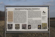
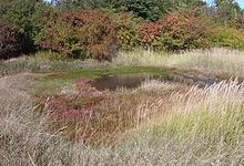
Salzgraben salt dahlum
The salt ditch near Salzdahlum is a natural monument near Salzdahlum , a district of Wolfenbüttel in Lower Saxony . In the biotope with the natural monument identifier ND WF 40, plants also grow that otherwise only occur near the coast of the sea. The salt ditch is located northeast of Salzdahlum at a junction of the road that leads to Sickte .
Emergence
In the Zechstein Age , around 255 million years ago, Northern Germany was a shallow sea basin, the Zechstein Sea . Due to variable flooding over millions of years, the water in the basin evaporated and the salt it contained was deposited several hundred meters thick . When these salt deposits were overlaid by other rock layers in the Mesozoic Era , the pressure of the rock layers was so great that the salt was plastically deformed and pushed upwards in geological fractures, weak points and faults. It emerged salt domes or salt cushion that formed at the surface hills and mountains. Examples of this are the Asse or Elm , which are within sight, and which have been raised by the salt domes below. Aquiferous layers also came into contact with the salt domes and salt layers and obviously salty water is washed out to the surface of the earth at the Salzdahlum salt ditch .
history
The former saltworks was mentioned in a document in 888. The salt plant joined in the following centuries often its owners, including those were pen Steterburg , Riddagshausen Abbey or noble families. In 1385 it was fortified and secured against theft, as salt was of great economic importance at the time. When the dukes managed the salt works, it was repaired in 1835 and a graduation tower was built. The graduation house was abandoned due to a lack of fuel. At the end of 1852 the salt production stopped and the new owner, the domain leaseholder in Salzdahlum, operated a brick factory for a time . A sugar factory was built on the site in the 19th century and operated until the middle of the 20th century. Today, at the beginning of the 21st century, the area is used commercially. The salt ditch was preserved and was declared a natural monument in 1980 with an associated area at the northern end of the ditch, presumably an old salt pan.
vegetation
Today, the water-bearing salt ditch in particular points to the former saltworks. In addition to the ditch, vegetation has developed that is a geological and botanical peculiarity, because plants grow that are mostly only found on the sea coasts. The salinity of the leaked water is not very high and halophytes , salt-loving plants, grow . Typical halophytes occurring there are beach aster ( Aster tripolium ), beach milkweed ( Glaux maritima ) and salt chickweed ( Spergularia salina ). The dysentery flea herb ( Pulicaria dysenterica ) also grows there .
The preservation of this biotope is u. a. ensured by the fact that the BUND annually removes the wood and grass growth there.
Web links
- Description at Braunschweigische Landschaft on denkmalpflege.bsl-ag.de
- braunschweigischelandschaft.de (PDF; 260 kB): Information board at the salt ditch
- bund-bs.de : How to get to the salt ditch
Individual evidence
- ↑ a b Natural monuments in the Wolfenbüttel district. (PDF) (No longer available online.) Wolfenbüttel district , archived from the original on March 4, 2016 ; Retrieved April 22, 2015 . Info: The archive link was inserted automatically and has not yet been checked. Please check the original and archive link according to the instructions and then remove this notice.
- ↑ a b c d Salzgraben Salzdahlum natural monument. Braunschweigische Landschaft eV, AG Monument Preservation, accessed on April 22, 2015 .
Coordinates: 52 ° 11 ′ 56.3 " N , 10 ° 36 ′ 3.7" E


