Samha
| Samha | ||
|---|---|---|
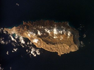
| NASA image of Samha | ||
| Waters | Guardafui Channel, Indian Ocean | |
| Archipelago | Socotra , al-Ichwan | |
| Geographical location | 12 ° 9 ' N , 53 ° 2' E | |
|
|
||
| length | 11.9 km | |
| width | 5.5 km | |
| surface | 40 km² | |
| Highest elevation | 780 m | |
| Residents | 100 (2004) 2.5 inhabitants / km² |
|
| main place | Samha | |
| Map of the Socotra Archipelago with Samha | ||
Samha ( Arabic سمحة, DMG Samḥa , also Samhah ) is the third largest and smallest inhabited island of the Socotra Archipelago in the north-western Indian Ocean . Politically, it belongs to the Socotra Governorate of the Republic of Yemen .
geography
The island is about 70 km east of Abd al-Kuri and 46 km southwest of Socotra , the main island of the archipelago. Samha and its neighboring island of Darsa in the east, 17 km away, are also called al-Ichwan /الإخوان / al-Iḫwān / means 'the brothers'. Samha is almost 12 km long, up to 5.5 km wide and has an area of about 40 km². The island has around 100 inhabitants (as of 2004) who live in the only place on the north coast.
Together with the three neighboring islands of the Socotra Archipelago, Samha has been a UNESCO World Heritage Site since 2008 .
Individual evidence
- ^ Socotra Archipelago. UNESCO, accessed July 2, 2017 .


