Sankelmarker See
| Sankelmarker See | ||
|---|---|---|

|
||
| Geographical location | Community Oeversee , Schleswig-Flensburg , Schleswig-Holstein , Germany | |
| Tributaries | Billau, Marienau | |
| Drain | Get to the Treene | |
| Islands | a | |
| Places on the shore | Sankelmark | |
| Data | ||
| Coordinates | 54 ° 42 '45 " N , 9 ° 25' 39" E | |
|
|
||
| Altitude above sea level | 25.33 m above sea level NN | |
| surface | 56.8 ha | |
| length | 1.6 km | |
| width | 500 m | |
| volume | 3,680,000 m³ | |
| scope | 4.69 km | |
| Maximum depth | 11.2 m | |
| Middle deep | 6.48 m | |
| Catchment area | 18.76 km² | |
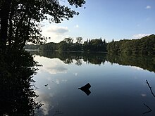
The Sankelmarker See ( Danish : Sankelmark Sø ) is located in the municipality of Oeversee in the north of Schleswig-Holstein , between the village of Oeversee and the district of Sankelmark .
description
It is a calcareous , despite its relatively large average depth of 6½ meters unstratified Tieflandsee with a catchment area of 18.76 square kilometers (lakes type 11). On its north bank it is fed by the two brooks Billau and Marienau, which are connected by ditches and between which the village of Sankelmark lies, as well as by springs on the bank and the bottom of the lake. In the south, a drain called Beek drains the lake to the Treene . There is an island near the western end of the lake, whose mean water level is 25.33 meters above sea level . The lake, which probably emerged from a subglacial gully as part of the Südensee-Treßsee gully during the Vistula glacial period , got its current size of 56 hectares due to a drop in the water level of 1.1 meters in 1937. T. falsely claimed to be a dead ice hole . The lake is known for its coloration, which is different depending on the season, caused by cyanobacteria . In spite of the fact that agriculture is carried out up to the immediate bank border, partly in rapeseed monocultures (which at least tolerates border strips of hedges, which therefore seem to respect EU law), amphibians such as the common toad can be found in the lake area alongside numerous bird and fish species .
See also
Web links
- Ministry of Agriculture, Environment and Rural Areas Schleswig-Holstein: Agriculture and Environment Portal: Sankelmarker See , there are linked to reports on plankton, flora and fauna
Remarks
- ↑ Lake type 11: Lime-rich, unstratified lowland lake with a relatively large catchment area, dwell time> 30 days, see Federal Environment Agency: Lake typology in Germany ( Memento from 9 September 2013 in the Internet Archive )
Individual evidence
- ↑ a b c d e f g h Ministry for Agriculture, Environment and Rural Areas Schleswig-Holstein Agriculture and Environment Portal: Sankelmarker See, characteristic data , accessed on December 28, 2011
- ↑ a b c d e map of the catchment area , accessed on December 28, 2011
- ↑ a b c 100 years of the Sankelmark fishing club. in Treene-Spiegel No. 393, December 2008 (PDF, 5 MB), pages 15–16, accessed on December 28, 2011
- ^ A b Wünnemann, B. (1993): Results on the Young Pleistocene development of the Langseerinne Südangeln in Schleswig-Holstein In: Berliner Geographische Abhandlungen 55


