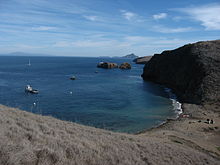
Santa Cruz Island
| Santa Cruz Island | ||
|---|---|---|
| Santa Cruz Island satellite image | ||
| Waters | Pacific Ocean | |
| Archipelago | Channel Islands | |
| Geographical location | 34 ° 0 ′ N , 119 ° 44 ′ W | |
|
|
||
| length | 35 km | |
| width | 10 km | |
| surface | 245.42 km² | |
| Highest elevation |
Devils Peak 747 m |
|
| Residents | 2 (2000) <1 inh / km² |
|
| main place | Stanton Ranch | |
| Channel Islands map | ||
Santa Cruz Island is an island off the coast of California that belongs to the archipelago of the California Channel Islands .
Characteristics
At 245.42 square kilometers, it is the largest island in the Channel Islands and also the largest privately owned island in the United States . Santa Cruz Island is located in Santa Barbara County and is part of the Channel Islands National Park . The island reaches a height of 747 meters above sea level in Devils Peak and, according to the Census 2000, has two permanent residents.
history
Archaeological excavations suggest that the island was inhabited for at least 9,000 years. Chumash Indians established a highly complex society on the island. Although the island was discovered by Europeans before, there was no contact with Europeans until 1769, when an expedition led by Don Gaspar de la Portola reached Santa Cruz Island.
Literary processing
Santa Cruz Island is one of the main locations in the 2011 novel When the Killing's Done by the American author TC Boyle .
Web links
- Santa Cruz on the official site of the National Park (English)
- About the history of Santa Cruz (English)
Individual evidence
- ↑ a b Block 3000, Block Group 3, Census Tract 29.10, Santa Barbara County (English)
- ↑ Devils Peak on Peakbagger.com (English)
- ↑ Information at nps.gov
- ↑ Barnes and Noble Book Review (English); Accessed June 25, 2011


