Anacapa Island
| Anacapa Island | ||
|---|---|---|
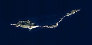
| Anacapa Island satellite image | ||
| Waters | Pacific Ocean | |
| Archipelago | Channel Islands | |
| Geographical location | 34 ° 0 '14 " N , 119 ° 23' 41" W | |
|
|
||
| surface | 2.947 km² | |
| Highest elevation |
Summit Peak 2 283 m |
|
| Residents | 3 (2000) 1 inh / km² |
|
| Channel Islands map | ||
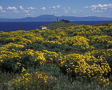
Anacapa Island is a small, elongated volcanic island about 14 miles off the west coast of California . The island belongs to the Channel Islands archipelago and is part of the Channel Islands National Park of the same name . The island is the only one of the Channel Islands whose name is not of Spanish origin. Anacapa Island is composed of three sub-islands ( East , Middle and West Anacapa ) and has an area of 2.95 km². On East Anacapa there is a visitor contact point of the national park, which is run by rangers and according to the Census 2000 has three permanent residents. The Anacapa Lighthouse is also located on East Anacapa .
People first lived on the island at least 12,000 to 13,000 years ago.
Geology, the three islands
Anacapa is predominantly of volcanic origin. Heavily weathered rock from the Miocene (about 23 to 5.3 million years ago) dominates the landscape. The island was probably unfolded, however, and many of the submarine lava flows are visible on the island. Sedimentary rocks are found only in a few places , such as the blue-green San Onofre breccia in the south of West Anacapa at Cat Rock. The extreme weather conditions and the surf formed numerous caves and holes. Apparently the islands extend the Santa Monica Mountains westward.
East Anacapa is the smallest of the three islets that make up Anacapa. It is practically an inaccessible mesa , the plateau of around 40 hectares is around 70 m above sea level. On the islet there is a lighthouse, a fog signal, park administration buildings and a campsite.
Middle Anacapa is the second largest of the three islands. It is around 5 km long, but rarely wider than 200 m. Some beaches on the south side are only accessible by boat, with East Fish Camp being the largest landing site. A few fishermen lived there at times. Access is possible on the north side in the central part of the island, but this is prohibited without the permission of the park administration.
West Anacapa rises highest and is the largest of the three islands that make up Anacapa. Access is only allowed in Frenchy's Cove. This protects the breeding grounds of pelicans and sea birds.
ecology
Anacapa Island is a major breeding ground for sea birds. After the black rat was introduced into the island ecosystem by humans on boats, large parts of the breeding areas were threatened. Around 70% of the clutches of the guillemot were eaten by rats. In 2003 the rats were exterminated using poison bait brought by the airplane. After ten years there has been a clear increase in the breeding bird population, and a brood of the monochrome wave walker has been observed on the island for the first time.
history
First residents
The Northern Channel Islands include, from east to west, Anacapa, Santa Cruz, Santa Rosa, and San Miguel Island. The archipelago has been subject to extremely strong changes since the last maximum of glaciation during the last glacial period , as the global melting of the ice masses caused the sea level to rise by 100 to 125 m. By then, at the lowest water level 20,000 years ago, the islands had merged into a single large island known as Santarosae Island . Its eastern edge (now Anacapa) was 6 to 8 km from the mainland. Today the islands are 20 to 42 km off the coast. Anacapa is the smallest with 2.6 km², and Santa Cruz is the largest with 249 km². Anacapa was 13,000 years ago 8.5 km from the coast, 11,500 years ago 10 km, 9,500 years ago 12 km and 9,000 years ago already 13 km.
People first lived on the islands no later than 13,000 to 12,000 years ago. One of the reasons why people must have repeatedly traveled the Pacific in sea vessels is the occurrence of flint and chert, which were of the greatest importance for the manufacture of weapons and tools. The deposits on Anacapa were of lower quality, but there was evidence of a stone blade industry there. A continuous settlement existed since 3000 BC at the latest. Chr.
In the 18th century Chumash lived on the archipelago, but there is no evidence of the settlement of Anacapa in the Spanish sources. At least 23 mussel mounds, a kind of garbage heap, are known on the islands.
designation
Among the names of the Channel Islands, only Anacapa does not go back to Spanish, but to Indian roots. In the language of Chumash meant eneepah or Anyapakh about Mirage Island . In 1770 Gaspar de Portolà mistook West Anacapa for the sail of a distant ship. Therefore he named the island Velo Falsa (false sail) and the neighboring islands Las Mesitas (the little tables). In 1774 Juan Perez renamed the archipelago Isletas de Santo Tomas, George Vancouver , adopted the sound of the Indian name as he heard it. So he took over the Chumash Eneeapah, but wrote “Enecapa” on his maps. Finally, the island appeared under its current name in the US Coast Survey in 1852. The first European to sail past the island was probably Juan Rodríguez Cabrillo in 1542 . Most explorers didn't even mention the small island on their maps.
Transfer to the USA and state property (1848), first non-indigenous residents, leases
In 1848 California and with it Anacapa came to the USA with the Treaty of Guadalupe Hidalgo . The island was always state owned, never private. Fishermen occasionally used it as a station and warehouse, a report in 1853 mentions an old house in the southern central part of the island. After the collapse of indigenous cultures, Captain George Nidever was the first to take an interest in the island. He kept sheep there. Although the island was owned by the state, it changed hands several times through buying and selling. For example, it acquired the Pacific Wool Growing Company .
It was not until 1902 that the government intervened and leased Anacapa to Louis Le Mesnager, who was followed in 1907 by Heaman Bayfield Webster, who increased the herd of sheep to 500 animals. He lived on the central part of the island with his wife and two sons until 1917. When in 1917 he tried to get Congress to extend his lease by 25 years, the threat of war in Europe meant that Congress was unable to deal with the matter, so the family lost their lease to Captain Ira Eaton. Eaton owned a resort on Santa Cruz Island and used Anacapa as a warehouse for illegal alcohol during the prohibition era. He also signed a sub-lease contract to the Santa Barbara Fish Company , which settled fishermen there. Anacapa had no tenant between 1927 and 1932, but Raymond "Frenchy" LaDreau lived as a hermit from 1928 to 1956 on the western end of the island. He became the unofficial reporter for the national park administration. He left the island at the age of 80. C. Fay Chaffe became the island's last tenant in 1932. In 1937 the government decided not to lease any more. Today only members of the Coast Guard and the National Park live on Anacapa.
Ship accidents, beacon (1911) and lighthouse (1932)
On December 2, 1853, the more than 75 m long steamship Winfield Scott of the Pacific Mail Steamship Company ran aground on the rocks north of Middle Anacapa en route from San Francisco to Panama and sank with a total of 2 million dollars in gold bars. The more than 400 passengers could be rescued after a week, even if the supplies were exhausted. From 1854, considerations began to build a lighthouse. Therefore, the island was administered by the Lighthouse Bureau until 1938. However, it was not until 1911 that an unmanned beacon was erected on a 17 m high tower at the east end of the island. In 1932, today's lighthouse was built at the entrance to the Santa Barbara Channel at a height of 277 feet, a little more than 90 m; he is the only one in the Channel Islands. The tower included 30,000 square feet of concrete to collect rainwater because there was no drinking water on the island. In addition, there were apartments for the servants, since until 1968 there was a turn by mainland crews. All but one were demolished in 1968 when operations were automated.
Protected status (1938), National Park (1980)
In 1938, Anacapa and Santa Barbara were given National Monument status by President Franklin D. Roosevelt . In 1939 the Lighthouse Bureau was dissolved and the island was handed over to the National Park Service . In 1978 the results of an extensive archaeological investigation were published. The Channel Islands National Park was created in 1980 , although some places on the island are claimed by the coast guard.
literature
- C. Rozaire: The bladelet industry on Anacapa and San Miguel Islands, California . In: MA Glassow (Ed.): Archeology of the Northern Channel Islands of California: Studies of Subsistence, Economics, and Social Organization . Coyote Press Archives of California Prehistory, Salinas 34, 1993, pp. 63-73.
Web links
- Anacapa on the side of the National Park (English)
- History of Anacapa Island . ( Memento of February 4, 2012 in the Internet Archive ) February 4, 2012
Individual evidence
- ↑ Block Group 8, Census Tract 36.04, Ventura County (English)
- ^ National Park Service: Channel Islands - Island Recovery Evident Ten Years after the Removal of Rats , press release March 7, 2013
- ↑ Nicholas Jew: Paleocoastal Resource Use and Human Sedentism in Island Environments: A Case Study from California's Northern Channel Islands , University of Oregon, June 2013, p. 9.
- ↑ Nicholas Jew: Paleocoastal Resource Use and Human Sedentism in Island Environments: A Case Study from California's Northern Channel Islands , University of Oregon, June 2013, p. 136.
- ↑ Nicholas Jew: Paleocoastal Resource Use and Human Sedentism in Island Environments: A Case Study from California's Northern Channel Islands , University of Oregon, June 2013, Tab. 7.1, p. 170.
- ↑ Nicholas Jew: Paleocoastal Resource Use and Human Sedentism in Island Environments: A Case Study from California's Northern Channel Islands , University of Oregon, June 2013, p. 52.
- ↑ Nicholas Jew: Paleocoastal Resource Use and Human Sedentism in Island Environments: A Case Study from California's Northern Channel Islands , University of Oregon, June 2013, p. 175.
- ↑ C. Rozaire: A Report on the Archeological Investigations of Three California Channel Islands: Santa Barbara, Anacapa and San Miguel . Archives E 78 U5c C45: 14, National Parks Service 1978.
- ^ TC Rick: A 5,000 year record of coastal settlement on Anacapa Island, California . In: Journal of California and Great Basin Anthropology . Volume 26, 2006, pp. 65-72.
- ^ Erwin Gudde, William Bright: California Place Names , 4th edition. University of California Press 2004, p. 12.
- ↑ a b Winfield Scott. Vessel history . Channel Islands National Marine Sanctuary.
- ^ Roberta S. Greenwood: Archeological Survey and Investigation. Channel Islands National Monument, California , ed. v. National Park Service. Denver Service Center, Greenwood and Associates, 1978.


