Saser Kangri II
| Saser Kangri II | ||
|---|---|---|
|
Saser Kangri II in the center of the picture |
||
| height | 7518 m | |
| location | Ladakh ( India ) | |
| Mountains | Saser Muztagh ( Karakoram ) | |
| Dominance | 8.39 km → Saser Kangri I | |
| Notch height | 1450 m ↓ ( 6068 m ) | |
| Coordinates | 34 ° 48 '16 " N , 77 ° 48' 27" E | |
|
|
||
| First ascent | on August 24, 2011 by Mark Richey, Steve Swenson, Freddie Wilkinson | |
|
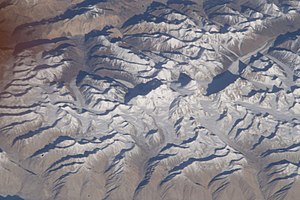
Image from the ISS, Saser Kangri II in the center right |
||
The Saser Kangri II is a mountain in the Saser Muztagh , a mountain range in the Indian part of the Karakoram .
The Saser Kangri II forms the second highest mountain in Saser Muztagh and the 47th highest mountain on earth. It has two peaks: Saser Kangri II East ( 7518 m ) and Saser Kangri II West ( 7511 m ). The distance between the two peaks is 460 m, the notch height 151 m.
The western summit of Saser Kangri II was first climbed in 1953 by Nawang Gombu from an Indo-Japanese rope team. The East Summit was first climbed on August 24, 2011 by Mark Richey, Steve Swenson and Freddie Wilkinson. Up to this point in time, the eastern summit of Saser Kangri II was the second highest unclimbed mountain on earth .
Web links
- Saser Kangri II on Peakbagger.com (English)
Individual evidence
- ↑ Emily Maynard: Saser Kangri II in Alpine styles. www.alpinist.com, September 15, 2011 , accessed September 15, 2011


