Sauce de portezuelo
| Sauce de portezuelo | ||
|---|---|---|
|
Coordinates: 34 ° 52 ′ S , 55 ° 8 ′ W Sauce de Portezuelo on the map of Uruguay
|
||
| Basic data | ||
| Country | Uruguay | |
| Department | Maldonado | |
| Residents | 128 (2011) | |
| Detailed data | ||
| Post Code | 20004 | |
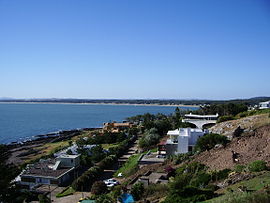
| View from Punta Ballena (in the foreground) to Portezuelos Beach | ||
| View from Casapueblo to Portezuelo (coastline on the horizon) | ||
Sauce de Portezuelo , also known as Portezuelo for short , is a town in Uruguay .
geography
It is located in the Maldonado department in sector 3 . Sauce de Portezuelo borders the coast of the Río de la Plata to the south , while Ocean Park connects to the east and La Capuera to the north . The Laguna del Sauce extends a few kilometers to the northeast . The Arroyo de la Barra Falsa flows west of Sauce de Portezuelo .
Infrastructure
The Ruta Interbalnearia / Ruta 93 leads past the northern edge of the village . A short distance to the northeast is the Capitán de Corbeta Carlos A. Curbelo Airport .
Residents
Sauce de Portezuelo had 128 inhabitants in 2011, 71 of them male and 57 female.
| year | Residents |
|---|---|
| 1963 | 41 |
| 1975 | 15th |
| 1985 | 19th |
| 1996 | 59 |
| 2004 | 63 |
| 2011 | 128 |
Source: Instituto Nacional de Estadística de Uruguay
Web links
- City map of Sauce de Portezuelo (PDF; 120 kB)
Individual evidence
- ^ Códigos Postales del Interior , accessed February 26, 2012
- ↑ Statistical data ( memento of September 7, 2012 in the Internet Archive ) of the Instituto Nacional de Estadística de Uruguay , accessed on September 27, 2012
- ↑ Statistical data of the Instituto Nacional de Estadística de Uruguay 1963–1996 (DOC; 127 kB)
- ↑ Statistical data from the Instituto Nacional de Estadística de Uruguay 2004 as an xls file ( Memento from March 9, 2013 in the Internet Archive )


