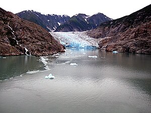
Sawyer Glacier
| Sawyer Glacier | ||
|---|---|---|
|
Sawyer Glacier (August 2008) |
||
| location | Alaska (USA), British Columbia (Canada) | |
| Mountains | Boundary Ranges ( Coast Mountains ) | |
| Type | Valley glacier | |
| length | 35 km | |
| Exposure | south | |
| Altitude range | 1900 m - 0 m | |
| width | ⌀ 1.8 km | |
| Coordinates | 57 ° 57 ′ N , 133 ° 0 ′ W | |
|
|
||
| drainage | Tracy Arm → Stephens Passage ( Pacific Ocean ) | |
| particularities | Tidal glaciers | |
The Sawyer Glacier is a 35 km long valley glacier in the Boundary Ranges in Alaska (USA) and British Columbia (Canada).
geography
The Sawyer Glacier is located 85 km southeast of Juneau in the Alaska Panhandle . The glacier drains part of the glacier area of the Stikine Icecap to the west towards the sea. The glacier's nutrient area is on the Canadian side north of Owens Peak at an altitude of about 1900 m . The glacier flows west and crosses the border into Alaska. Less than a kilometer above its confluence with the sea, it joins a tributary glacier coming from the west and turns south. The glacier tongue ends in a small side bay of the Tracy Arm . This represents a fjord that opens towards Stephens Passage . The Sawyer Glacier is in retreat and has already lost three kilometers in length at its lower end.
tourism
In contrast to that of the neighboring South Sawyer Glacier, the glacier tongue of the Sawyer Glacier is hidden in a side bay and is less spectacular.

