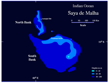
Saya de Malha
Coordinates: 10 ° 46 ′ S , 61 ° 16 ′ E
Saya de Malha Bank is a large flat water area of 40,808 km². This threshold is about as big as Switzerland and is located in the middle of the Indian Ocean , east of Madagascar , southeast of the Seychelles and north of the island of Mauritius .
The closest land is the Agalega Islands . Saya de Malha is administered by Mauritius , but it lies outside of national jurisdiction .
Saya de Malha consists of two separate units, the smaller North Bank (also Ritchie Bank) and the larger South Bank. Due to its location on the equator and the shallow water depth, which is often less than ten meters ( Poydenot Shoal 8 meters), the area is extremely biologically productive. However, little is known about its rich fauna and flora because of its remoteness. The Saya de Malha Bank is a marine area of great ecological value.
history
Saya de Malha is 35 million years old and is made of basalt overlaid with limestone . The limestone banks are on the plateau and are the remains of coral reefs . Millions of years ago the bank consisted of one or more mountainous islands of volcanic origin, similar to today's Mauritius or Réunion . Over time, the land sank below sea level due to geological processes. During the last ice age , when the sea level was up to 130 meters lower than today, there were several islands in this area.
The area was first mentioned by Portuguese explorers 500 years ago. On the voyage between the Cape of Good Hope and India , they noticed this flat sea area from the swaying green seagrass , after having previously only sailed through the deep blue Indian Ocean.
Saya de Malha was first explored in 1838 by Robert Moresby , an officer in the British-Indian Navy .
Since 1997 the researchers Wolf Hilbertz and Tom Goreau have been trying to create an artificial island in the area of Saya de Malha. They installed biorock structures in the area, that is, steel structures anchored to the seabed of the North Bank at a depth of eleven meters. The system is supplied with the necessary electricity for the intended mineral accretion via a connected photovoltaic system , thus creating the basic structure of an island.
Individual evidence
- ↑ Wolf Hilbertz, Visionary of the Sea ( Memento from March 16, 2009 in the Internet Archive )
- ↑ PDF of the Saya de Malha Expedition 2002, rev. 1 (PDF 2.2 MB, English)
literature
- John Ryan, Micronations , Publisher: Lonely Planet Publications, ISBN 978-1741047301
Web links
- Artificial coral reef project in the Pemuteran Bay on Bali (PDF 2.42 MB, German)
- scinexx the knowledge magazine

