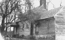
Sayler's Creek Battlefield
Coordinates: 37 ° 18 '16 " N , 78 ° 13' 43" W.
Sayler's Creek Battlefield near Farmville , Virginia was the site of the fighting at Sailor's Creek during the Civil War . Robert E. Lee's army withdrew its front line from Richmond to Petersburg at this stage of the war . Here on April 6, 1865, Union General Philip Sheridan cut off about a quarter of Lee's army and pushed them back. Eight Confederate generals surrendered and 7,700 soldiers fell or were captured. The fighting that day was the last major battle of the Civil War, and General Lee's surrender at Appomattox came three days later. Part of the battlefield, classified as a National Historic Landmark , is part of Sailor's Creek Battlefield Historical State Park .
The area was named after a farmer named Saylor in the 18th century. During the Civil War , the spelling Sayler was established ; however, some official documents use the spelling Sailor . This is how the state of Virginia named the state park .
The battle consisted of three separate skirmishes, the skirmish at Hillsman's Farm, the skirmish at Marshall's Cross Roads (or skirmish at Harper's Farm) and the skirmish at Lockett's Farm (or skirmish at Double Bridges). The Hillsmans house was used as a hospital for Union and Confederate troops after the battle. Traces of blood can still be seen on the floor today. The Lockett's farmhouse is still in its original state.
There are four parts to the area classified as NHL; these are 800 acre , 215 acre, 5 acre and 0.6 acre in size . These are marked on topographic maps that accompany the Virginia Department of Historic Resource's version of the NRHP documents . Of that total, only 321 acres are contained in the current state park.
The National Historic Landmark is located at Virginia Routes 617, 618, and 619 in Farmville , Amelia County and Burkeville , Prince Edward County . Between 1865 and when the area was nominated for inclusion on the National Register in 1984, the area developed little and remained largely as it had been during the fighting. Declared a National Historic Landmark and listed as a site on the National Register of Historic Places , the battlefield was declared in February 1985.
Park guides in historical costumes explain the various stations in the park. The battle is re-enacted every year on the anniversary of the battle in April.
supporting documents
- ↑ a b c Christopher M. Calkins: National Register of Historic Places Inventory-Nomination: Sayler's Creek Battlefield ( English , PDF ,; 1.5 MB) National Park Service. June 1984. Retrieved April 30, 2012. (including six maps explaining the battle) and four accompanying photos from 1936 (PDF, 32 KB)
- ↑ Photos of the site of the Battle of Sayler's Creek
- ↑ Sayler's Creek Battlefield ( English ) In: National Historic Landmark summary listing . National Park Service. Retrieved May 9, 2012.
- ↑ Christopher M. Calkins: National Register of Historic Places Inventory-Nomination: Sayler's Creek Battlefield ( English , PDF ,; 6.0 MB) National Park Service. June 1984. Retrieved May 9, 2012. (includes six maps detailing the battle and topographic maps showing the four areas of the National Historic Landmark)
- ↑ Listing of National Historic Landmarks by State: Virginia. National Park Service , accessed March 8, 2020.
- ^ Sayler's Creek Battlefield on the National Register of Historic Places , accessed March 8, 2020.
- ↑ Archived copy ( Memento of the original dated May 11, 2008 in the Internet Archive ) Info: The archive link was inserted automatically and has not yet been checked. Please check the original and archive link according to the instructions and then remove this notice. pg.9
Web links
- Sayler's Creek Battlefield, Amelia County , a photo on the Virginia DHR website


