
Sulzbach pumping station
| Sulzbach pumping station | |
|---|---|
 View from the northwest |
|
| Data | |
| place | Mariaposching |
| Construction year | 1934 |
| Coordinates | 48 ° 51 '3.4 " N , 12 ° 50' 31" E |
| particularities | |
| Monument: file no .: D-2-78-149-15 |
|
The Sulzbach pumping station is a listed building for flood protection in the Mariaposching community .
The flood pumping station stands in a single location on the Mariaposching district on the right backwater dike of the Schwarzach tributary to the Danube . It was built in 1934 to protect the dike hinterland against flooding during floods of the Danube . The outflows from a part of the Sulzbach polder run over the Schardengraben , Saßgraben , Rißgraben and Sommersdorfer Graben to the pumping station and from here, at low and medium water levels, the Schwarzach continues in open water over a sluice into the river. A trench system to the east is also hydraulically connected to the pumping station via a culvert under the Schwarzach drainer. When the Danube floods and the resulting backwater in the Schwarzach, the sluice is closed and the pumps of the pumping station deliver up to 6.0 m³ / s of the inflowing water via a pressure shaft into the diked Schwarzach. The permissible inland water level at this point is 310.71 m above sea level. NN .
The Mariaposching and Sommersdorf pumping stations still exist in the Mariaposching community .
Architecture and history
The single-storey solid building has a floor area of over 100 square meters and is aligned along the inside of the dike. On the western long side, a square tower similar to a transformer tower station is inserted approximately in the middle, at which a three-part overhead line ends. The pyramid roof of the tower and the hipped roof of the pump house drop from the ridge at an angle of about 45 degrees, after a kink they run out quite flat towards the eaves. The feed system with grinding busses is to the west, separated from the building by a back dike path . The pumping station was placed under monument protection on July 13, 2010 by the Bavarian State Office for the Preservation of Monuments.
Renaming and extension
In connection with the planned improvement of the flood protection to the degree of protection HW 100 , more pumping capacity is required. These are to be close to the stock pumping station Sulzbach I supplementing new pumping station Sulzbach II are built with a pumping capacity of 6.8 m³ / h.
gallery

Mahlbusen

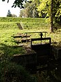
Siel and pressure shaft
Culvert on the eastern dike


Web links
- List of monuments for Mariaposching (PDF) at the Bavarian State Office for Monument Preservation
- BayernAtlas of the Bavarian State Government ( information )
Individual evidence
- ↑ plan approval; Appendix 2; Federal waterway Danube; Expansion of the waterway and improvement of the Straubing-Vilshofen flood protection; Section 1: Straubing-Deggendorf. (PDF) Explanatory report. (No longer available online.) Federal Waterways and Shipping Administration , August 1, 2014, p. 27 , archived from the original on September 10, 2014 ; accessed on October 20, 2016 . Info: The archive link was inserted automatically and has not yet been checked. Please check the original and archive link according to the instructions and then remove this notice.
- ↑ plan approval; Appendix 2; Federal waterway Danube; Expansion of the waterway and improvement of the Straubing-Vilshofen flood protection; Section 1: Straubing-Deggendorf. (PDF) Explanatory report. (No longer available online.) Federal Waterways and Shipping Administration , August 1, 2014, p. 28 , archived from the original on September 10, 2014 ; Retrieved March 25, 2015 . Info: The archive link was inserted automatically and has not yet been checked. Please check the original and archive link according to the instructions and then remove this notice.
- ↑ plan approval; Appendix 2; Federal waterway Danube; Expansion of the waterway and improvement of the Straubing-Vilshofen flood protection; Section 1: Straubing-Deggendorf. (PDF) Explanatory report. (No longer available online.) Federal Waterways and Shipping Administration , August 1, 2014, p. 18 , archived from the original on September 10, 2014 ; accessed on October 20, 2016 . Info: The archive link was inserted automatically and has not yet been checked. Please check the original and archive link according to the instructions and then remove this notice.
- ↑ plan approval; Appendix 2; Federal waterway Danube; Expansion of the waterway and improvement of the Straubing-Vilshofen flood protection; Section 1: Straubing-Deggendorf. (PDF) Explanatory report. (No longer available online.) Federal Waterways and Shipping Administration , August 1, 2014, p. 31 , archived from the original on September 10, 2014 ; accessed on October 20, 2016 . Info: The archive link was inserted automatically and has not yet been checked. Please check the original and archive link according to the instructions and then remove this notice.