Scharyn
|
Sharyn River Шарын, Чарын (Charyn) Шолкодагсу (Scholkodagsu) Кеген (Kegen) |
||
| Data | ||
| location | Almaty ( Kazakhstan ) | |
| River system | Ili | |
| Drain over | Ili → Lake Balkhash | |
| source |
Ketmen Mountains 43 ° 1 ′ 25 ″ N , 79 ° 58 ′ 47 ″ E |
|
| muzzle |
Ili coordinates: 43 ° 55 '52 " N , 79 ° 25' 39" E 43 ° 55 '52 " N , 79 ° 25' 39" E
|
|
| length | 427 km | |
| Catchment area | 7720 km² | |
| Outflow location: 84 km above the mouth |
MQ |
35.4 m³ / s |
| Reservoirs flowed through | Moinak reservoir | |
| Small towns | Kegen | |
|
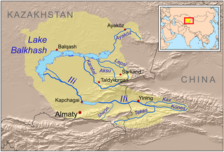
Course of the Scharyn (English Sharyn) in the catchment area of Lake Balkhash |
||
The Sharyn River ( Kazakh Шарын , Russian Чарын (Charyn)) is a left tributary of the Ili area Almaty in Kazakhstan .
The Scharyn rises on the southern slope of the Ketmen Mountains (Хребет Кетмень). In the upper reaches it is also called Scholkodagsu (Шолкодагсу), in the middle reaches Kegen (Кеген). It initially flows in a westerly direction through a high valley. The Scharyn later reaches the Moinak reservoir . The associated hydropower plant has an output of 300 MW . Now, the river turns northeast and flows through the Sharyn Canyon located Sharyn River Gorge . Finally the Scharyn reaches the Ili, into which it flows on the left. The Scharyn has a length of 427 km. It drains an area of 7720 km². In the winter months, the Scharyn is covered with ice. The river's water is used for irrigation .

