
Lehesten slate park
The Thuringian Slate Park Lehesten is a historic open cast slate mine with all its unique functional buildings and is now a technical monument in the mining and slate town of Lehesten in the Thuringian district of Saalfeld-Rudolstadt . There is also a conference and seminar center of the same name on the area of the slate park. The approximately 105 hectare area is located on the Thuringian-Franconian Slate Road south of Lehesten not far from the border with Bavaria in the Thuringian Slate Mountains / Obere Saale Nature Park . The slate was quarried as early as the 13th century, later extracted in small quarries and over time led to what was once the largest open cast slate mine on the European mainland. From 1975 onwards it was only mined underground.
history
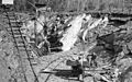
Mining
From the 13th century to 1999 slate was mined in today's state break near Lehesten in the south-east of the Thuringian Forest and processed into roof and wall slate as well as slates . The use of slate from Lehesten for roofing is documented as early as 1485. Initially, citizens were enfeoffed with a quarry, later the slate quarry went to the rule of Coburg and the Duchy of Saxony-Meiningen , after 1920 it was a breach of the state . During the boom between 1870 and 1910, up to 2,500 people were employed in the opencast mine and in the adjacent quarries. From 1885 the slate was transported on the Ludwigsstadt – Lehesten railway line .
Todays use
From 1999, after the end of the slate mining, the United Thuringian Schiefergruben GmbH founded today's Lehesten Slate Park, which has been managed by the voluntary "Thuringian Slate Park Lehesten" (TSL) foundation since 2000.
The technical monument "Historischer Schieferbergbau Lehesten" was opened in 1993 and can be visited by guided tours, also by former miners. Offered hotel and apartments, as well as tours of the preserved heritage-listed industrial building, including through the flashy and since 1840 obtained at the original site Göpel pit , demonstrations of historic slate mining, splitting and cutting the material and the production of slates.
The entire slate park area Staatsbruch is an FFH - and since 2001 a designated nature reserve . In this partly inaccessible area, 170 species on the Red List alone have now been proven , including the eagle owl . A lake over 40 meters deep was created in the former open-cast mine. A nature park exhibition was set up in the historic former Schacht II building, which shows the animals and plants that live in the adjacent Staatsbruch nature reserve. It is part of the "Historical Slate Mining" geological trail.
National geotope and showcase of geological history
This is the former Lehesten roof slate mine. Its dimensions alone are impressive; Together with the nearby Oertelsbruch, it is one of the former largest slate quarries on the continent (about 800 m in length, 300 m in width and up to 80 m in depth). The remaining hole area covers the upper Devonian-Lower Carboniferous strata from the Clymenia strata (doSC) to the Hasenthal strata (cdLH). In particular the Lehesten series with the soot slate and the main roof slate store as well as the Hasenthal layers (lower border slate) are excellently exposed.
The core of the geotope is the hand-cut, between 30 and 40 m high seigere rear wall of the "Kießlich" open-cast mining area below the Göpel. Their easily accessible N-joint shows the lying layers of the roofing slate in a flat tilted position and the main part of the roofing slate with its conductive layers and the shingling tectonics in a very good state of preservation.

Flooded open-cast mine in the area of the former quarry. In the background: parts of the former mine buildings

Historic Göpel shaft in Lehesten
Lehesten slate quarry


Web links
- Website of the technical monument "Historischer Schieferbergbau Lehesten"
- schieferpark.de | Website of the conference and seminar center Schieferpark
- Website on the history of the slate quarry and the NSG Staatsbruch ( Memento from September 14, 2016 in the Internet Archive )
- Nature park exhibition at www.lehesten.de. Retrieved August 29, 2020 .
Coordinates: 50 ° 27 '47.1 " N , 11 ° 26' 18.2" E