
Sanding marks (Malta)

Carts - or marks on Malta (English cart rut phenomenon ) are furrows that from prehistoric times in the history of Malta originate. The background to their creation is controversial.
description
The grinding marks are parallel scrapes in the limestone . Examples include the Clapham Junction near Buskett Gardens , the Ta 'Lambert Cart Ruts, and the Ta' Cenc and Ras il-Qala Cart Ruts in Gozo . Its course can be followed in 150 places in the low vegetation highlands of Malta, sometimes over hundreds of meters.
gallery
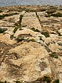
Grinding tracks on the west coast of Gozo, leading into the sea

Grinding marks on the west coast of Gozo
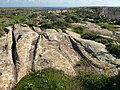
Grinding marks on the Ta 'Ċenċ Plateau (Gozo): A fork

Grinding marks on the Ta 'Ċenċ plateau (Gozo)


Age
The age of the grinding marks is difficult to determine. However, since they are interrupted in Malta by (presumably) Punic grave shafts, they must date from the time before the Punic settlement. This is supported by the fact that they also occur in the vicinity of some Neolithic temples, namely Ħaġar Qim , Mnajdra , Tal-Qadi , Tarxien , Skorba and Borg l-Imramma . So they could be much older. Since they cluster or converge in front of Bronze Age settlements (Qala Hill, Misraħ Ghonoq, Wardija ta'San Ġorġ and Borġ in-Nadur), their emergence during the Maltese Bronze Age (2300–1000 BC) is probably the one Resettlement of 2500 BC BC abandoned archipelago from Sicily preceded.
Hypotheses on the origin

Transport system
The routes run from valleys over low passes into neighboring valleys or towards settlements, as if they were to connect arable land and storage areas. Hence, it is believed that the furrows were part of a transportation system that spanned the islands.
Conceivable - and from a much older time in Western and Central Europe as well as carts and wagons - are rod loops , consisting of two rigidly connected wooden beams pulled by oxen . At the end of the beams, runners (possibly made of bronze , because wood was already in short supply in Malta at that time), which dug the characteristic depressions in the ground. The grooves of the double tracks are on average 1.1 meters apart, in bends up to 1.3 meters. They cut up to 0.4 meters deep into the karst , while there are no traces of draft animals , which is a problem with the cart-track theory: the animals' hooves would have the rock in a period of time during which such deep excavations were created, also have to leave permanently.
The use of sleds that could not negotiate these curves is also to be completely ruled out . In addition to the simple and frequent parallel double lanes, there are also forks and junctions. Sometimes the ground is so deeply furrowed that it looks like the track systems of modern marshalling yards. The many grooves that run down the slope at Clapham Junction and are cut halfway up by a pair of tracks are hard to imagine as rails of a transport system, since they end at the sea. So at the moment there are no rational motives for using the furrows.
irrigation
The hypothesis that it is an irrigation system has recently been supported again. Gozo has four major parts of these furrows. East of Qala at Tan-Nemes , a couple walk on a spur that overlooks Fliegu ta 's Gawdex . At Ta 'Tingi , south of Xewkija , there are several pairs in the olive grove west of the pumping station. An extensive system covers the Ta'-Ċenċ Plateau , best seen between the hotel and the cliffs. These furrows pass near Borg l-Imramma and continue for almost a kilometer to the east. A pair of zigzags line the slope of the San Lawrenz quarries. They end on the cliffs above the former Azure Window at Dwejra Point. Maltese fishermen and the historian D. Bradley claim to have seen them on the tiny rocky island of Filfla , off Malta, before they were destroyed by bombs .
Sanding marks outside of Malta
Such traces can be found not only on Malta and Gozo , but also on the Abşeron Peninsula in Azerbaijan , on the Azores , in the Balkans , at the Anse de St. Croix in France , in El Padul and Castellar de Meca in Spain , in Southern Italy (Agrigento, Matera), as well as Sardinia ( Su Crucifissu Mannu ) and Sicily . Portugal has several good examples of wagon tracks that run across the Serra d'Estrela mountains. Another type of ruts (shorter but up to five parallel) are the Queseras in the Canary Islands , which have their role models in Morocco .
literature
- Joachim von Freeden: Malta and the architecture of its megalithic temples. Scientific Book Society, Darmstadt 1993, ISBN 3-534-11012-9 .
- Abbas Islamov and Ronnie Gallagher: Cart Ruts and Stone Circles. Key Evidence from the Past Is Endangered. (English), general article on abrasive marks, published in Azerbaijan International Magazine , Fall 2002 issue
- Gordon E. Weston: The Maltese Cart-Ruts 2010, ISBN 978-99957-20-68-1
- Johannes Horn: The Mystery of Malta: The Cart-Ruts reveal their secret. 2007, ISBN 978-3935910392 .
Web links
Individual evidence
- ↑ Uwe Topper: The legacy of the giants (Olten, Switzerland 1977) chap. 11
- ↑ see Topper, Uwe: Felsengleise - new access www.chronologiekritik.net
- ↑ http://www.ancient-wisdom.com/portocartruts.htm
- ↑ Atlantis Rising, James Cameron (National Geographic, 2017)