Castle rock (stone forest)
| Castle rocks | ||
|---|---|---|
|
Red foxglove, growing wild in front of the castle rock |
||
| height | 913 m above sea level NHN | |
| location | Tirschenreuth district , Bavaria , Germany | |
| Mountains | Steinwald , Fichtelgebirge | |
| Coordinates | 49 ° 54 '48 " N , 12 ° 4' 6" E | |
|
|
||
|
Granite rock group Schloßfelsen |
||
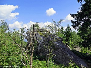
The castle rock lies on the ridge of the stone forest on the red and white marked hiking trail (stone forest path) between the ruins of Weißenstein and the Upper Palatinate Tower at 913 m above sea level. NHN.
The rock itself is over 20 m high and consists of granite, it is a habitat for rare animal species such as the adder.
The existence of a castle Zwerenz, once built by the whale pots, is controversial.
literature
- Karlheinz Hengst: The Walpoten - Critical consideration of a name and its Mainwendic interpretation . Archive for the history of Upper Franconia, 80th volume 2000, pp. 31–40
- Harald Stark : The whale pots between Radenzgau and Nordgau - A contribution to the "Zwerenz problem" .
- Erich Schraml: The whale pots in the stone forest? Der Siebenstern 1997, pp. 63-72
- Dietmar Herrmann: Lexicon Fichtelgebirge . Ackermann Verlag Hof


