Schmooksberg
| Schmooksberg | ||
|---|---|---|
|
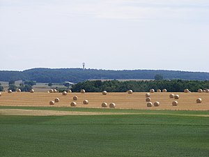
Landscape on Schmooksberg with mountain and radar station |
||
| height | 127.5 m above sea level NHN | |
| location | Mecklenburg-Western Pomerania , Germany | |
| Coordinates | 53 ° 50 '17 " N , 12 ° 22' 58" E | |
|
|
||
| Type | glacial terminal moraine | |
The Schmooksberg , also Schmocksberg (with expansion-c ), is a mountain with a height of 127.5 m above sea level. NHN in the Rostock district in Mecklenburg-Western Pomerania between Teterow and Laage in the area of the communities Plaaz and Laage.
location
The mountain lies east of Plaaz and southwest of the Diekhofer districts of Drölitz and Lüningsdorf. In the south, the district of Neu Zierhagen joins the community of Lalendorf . The highest point of the elevation is on the Diekhofer municipality.
Due to its isolated location, the mountain protrudes noticeably above the surroundings despite its relatively low altitude. The area around the summit itself is wooded, but from the flanks of the mountain you have a wide view in the corresponding directions, for example to Warnemünde 40 kilometers away . Despite several lakes and cultural and historical sites ( Recknitz village church , Rossewitz manor ), the area is barely developed for tourists.
history
In the Middle Ages, the mountain was considered a witch cremation site. This is considered to be a possible explanation of the name (derived from the Low German word for smoke, Schmok ).
The striking location made it attractive for military use for a long time. It served as a radar station for the Soviet army until the 1980s .
Today one of six SREM radar systems from the German air traffic control system is located on the mountain .
In the first half of the 2000s, the open-air festival Rock am Schmooksberg took place several times in Plaaz in the summer .

