Hatching
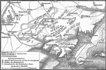
Hatching or mountain lines are a method of representing the terrain in topographic maps ( maps ). Specially arranged and designed lines illustrate the inclination or shadow of a terrain shape. Such hatching can be found above all in historical maps of the 19th century that were produced using lithography or copperplate engraving .
Embankment hatches run in the direction of the steepest slope ( fall line ) and vary in length and width. The stronger the gradient, the stronger and denser the hatching will be. Shadow hatches simulate a fall of shadow by illuminating the area from the northwest.
In contrast to hatches, hatches are surface patterns with regular shapes and spaces.
Hatching gives an extremely vivid picture of the terrain, but it also has disadvantages:
- Exact height information is not legible, it must be shown separately by height points.
- In densely shaded areas ( steep slopes , high mountains) it is difficult to find additional information (paths, buildings).
- The gradient is emphasized too much on the maps, creating a stepped impression of the terrain.
Because of these disadvantages, they were replaced on large-scale maps in the course of the 19th and 20th centuries by contour lines or hillshading or a combination of both. In small-scale maps, the hatching is often replaced by a colored elevation (see regional color ).
See also
- Terrain (cartography)
- Special cards from the 19th century
- Topographic map of Switzerland (shaded areas in the "Swiss manner")
- Johann Georg Lehmann (geodesist) ( Lehmann's hatches )
- Hillshade
Web links
swell
- ^ Peter Kohlstock: Cartography . 2nd edition, Schöningh, Paderborn 2010. ISBN 978-3-506-71710-8 . P. 90


