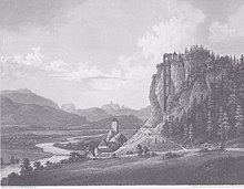
Federaun scrap tower

View of Federaun with the scrap tower by Markus Pernhart (1863)
The scrap tower Federaun was a scrap tower in today's Villach district of Federaun .
The scrap tower was built in 1824 by a company Moritsch, whereby the natural conditions were exploited by building the tower in the form of an oriel on a rocky eruption of the Dobratsch south face (grass ducts). In 1870 it was bought by the Bleiberger Bergwerks Union , which modernized the facility by installing a new sorting system and employed five people there in 1875. In 1887 it was shut down.
Today only remains of walls are visible at the head and foot of the rock face, which are listed ( list entry ).
There are contemporary views by Markus Pernhart (1863) and Josef Willroider (1879).
literature
- Georg Lux, Helmuth Weichselbraun: Derelict & Forgotten - Lost Places in the Alps-Adriatic Region. Styria Publishing House. Vienna / Graz / Klagenfurt 2017, ISBN 978-3-222-13551-4 .
Web links
- Representation of Pernhart (1863) on page 2 by Reinhold Gasper, Friedrich Hans Ucik: The former scrap tower near the Hollenburg (Southern Carinthia) and the other scrap towers in Carinthia and Austria, previously unknown in the specialist literature. In: Carinthia II. Klagenfurt 2006, pages 85-91, online on ZOBODAT
- Representation of Willroiders (1879) on page 5 by Friedrich Hans Ucik: The Carinthian mining industry in old artistic views. , P. 5, online at ZOBODAT
Individual evidence
- ↑ Between State and Market: History of the Bleiberger Bergwerk Union and ... - Thomas Zeloth - Google Books. In: books.google.at. Retrieved January 29, 2017 .
- ^ A b c Friedrich Hans Ucik: The Carinthian mining industry in old artistic views. , P. 5, PDF on ZOBODAT
- ↑ a b c Reinhold Gasper, Friedrich Hans Ucik: The former scrap tower near the Hollenburg (Southern Carinthia) and the other scrap towers in Carinthia and Austria, which was previously unknown in the specialist literature. In: Carinthia II. Klagenfurt 2006, pages 85–91, PDF on ZOBODAT
Coordinates: 46 ° 34 ′ 16 " N , 13 ° 48 ′ 50.3" E
