
Federaun
|
Ober- and Unterfederaun ( locality ) cadastral municipality Federaun |
|||
|---|---|---|---|
|
|||
| Basic data | |||
| Pole. District , state | Villach (VI), Carinthia | ||
| Judicial district | Villach | ||
| Pole. local community | Villach | ||
| Coordinates | 46 ° 34 '19 " N , 13 ° 48' 32" E | ||
| Area d. KG | 13.62 km² | ||
| Statistical identification | |||
| Cadastral parish number | 75411 | ||
| Source: STAT : index of places ; BEV : GEONAM ; KAGIS | |||

Federaun (Slov. Vetrov ) is a cadastral community of Villach at the exit of the Gail Valley .
The localities Oberfederaun, Unterfederaun, Oberschütt and Unterschütt are in the area of the cadastral community .
A former Roman path ( Via Julia Augusta ), which is now used as a hiking trail, leads from Federaun to Warmbad . Here the up to 20 cm deep driving grooves of the Roman mail wagons can be seen. The Federaun castle ruins are located on a steep rock above the village .
As a result of the earthquake of 1348 , there was damage in Federaun.
The name Federaun is derived from the Romanesque form "Vederona", which means something like "weather area".
On the western outskirts of Unterfederaun is the Gothic branch church of Federaun .

Rocks over Unterfederaun
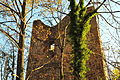
Keep of the Federaun castle ruins
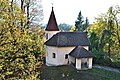
Filial church of St. Matthew in Unterfederaun

Gasthof "Kreuzwirt" in Unterfederaun No. 12

Detail at the “Kreuzwirt” inn in Unterfederaun No. 12

Trade union center in Unterfederaun No. 14 from 1750

Motorway bridge in Unterfederaun


swell
- ^ Heinz-Dieter Pohl , Birgit Schwaner: untitled . Retrieved on September 15, 2009 (presentation of “The Book of Austrian Names” ( ISBN 9783854314424 )).
- ↑ without title. (PDF; 146 kB) (No longer available online.) Office of the ethnic groups of the Province of Carinthia, p. 8 , archived from the original on December 21, 2014 ; Retrieved September 15, 2009 . Info: The archive link was inserted automatically and has not yet been checked. Please check the original and archive link according to the instructions and then remove this notice.
- ↑ Dvojesična Koroška - bilingual Carinthia. Retrieved September 15, 2009 .
- ↑ Carinthia's cultural assets - castles, fortresses, fortifications. Office of the Carinthian Provincial Government - Dept. 20 Provincial Planning, accessed on October 14, 2009 : "Federaun - District: Villach - Municipality: Villach"
- ↑ Change of the land use plan of KG Federaun. (No longer available online.) Villach.gruene.at, January 16, 2002, formerly in the original ; Retrieved October 14, 2009 . ( Page no longer available , search in web archives ) Info: The link was automatically marked as defective. Please check the link according to the instructions and then remove this notice.
- ^ Ernst Steinicke: Kanaltal Collection - A. LG. between Villach and Pontafel. Retrieved on October 14, 2009 : "The cadastral communities of Hart and Riegersdorf correspond to your court Krainegg, the cadastral community of Federaun to the keep of the same name."
- ↑ Verena Grader, Martin Kastner: Nature reserve (NSG) and landscape protection areas (LSG) of the Villacher Alpe (Dobratsch) - central area, Gailtal. (doc; 627 kB) In: Carinthia - a travel and culture guide. P. 14 , accessed October 14, 2009 .
- ^ Christa Hammerl : The earthquake of January 25th, 1348: discussion of sources # Conclutions. Retrieved September 14, 2009 .
- ^ Eberhard Kranzmayer: Place name book of Carinthia.