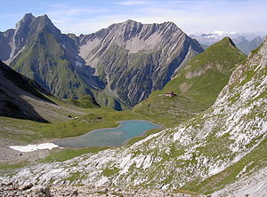
Seekogel (Lechtal Alps)
| Seekogel | ||
|---|---|---|
|
Seekogel on the right of the Memminger Hütte , on the left Freispitze and in the middle of the picture Saxerspitze |
||
| height | 2412 m above sea level A. | |
| location | Tyrol , Austria | |
| Mountains | Lechtal Alps | |
| Dominance | 0.88 km → Raue Spitze | |
| Notch height | 180 m ↓ Unterer Seewissee | |
| Coordinates | 47 ° 12 '16 " N , 10 ° 28' 33" E | |
|
|
||
The Seekogel ( 2412 m above sea level ) is the local mountain of the Memminger Hütte in the Lechtal Alps . The mountain is located northwest of the hut and can be reached from there in 25 minutes on the marked trail.
The European long-distance hiking trail E5 leads through the eastern flank of the Seekogel. The summit is often climbed in connection with this long-distance hiking trail.
Literature and map
- Dieter Seibert: Alpine Club Leader Lechtal Alps . Munich 2002, ISBN 3-7633-1268-4
- Alpine club map 1: 25,000, sheet 3/3, Lechtal Alps, Parseierspitze

