
Semeru
| Semeru | ||
|---|---|---|
 |
||
| height | 3676 m | |
| location | Java , Indonesia | |
| Mountains | Tengger massif | |
| Dominance | 390 km → Rinjani | |
| Notch height | 3676 m | |
| Coordinates | 8 ° 6 '28 " S , 112 ° 55' 12" O | |
|
||
| Type | Stratovolcano | |
| Last eruption | 2010 (ongoing) | |
| particularities | highest mountain in Java | |

Semeru , also known as Mahameru ("Great Meru "), is a stratovolcano and at 3676 m , the highest mountain on the Indonesian island of Java . It has a crater diameter of around 500 meters.
The volcano is located in the eastern part of the island southeast of Surabaya in the Bromo-Tengger-Semeru National Park . It is considered to be one of the most beautiful, but also one of the most active and dangerous volcanoes in the world. Since 1800 there have been more than 50 eruptions, including 10 major ones. The last eruption phase began in 1967 and continues to this day.
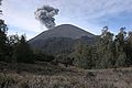
Semeru, clouds of smoke from afar
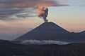
Semeru, clouds of smoke in twilight
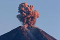
Semeru, clouds of smoke and peaks
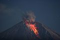
Semeru, darkness lava flow


Web links
Commons : Semeru - collection of images, videos and audio files
- Semeru in the Global Volcanism Program of the Smithsonian Institution (English)