Sempt flood canal
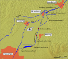
The Sempt flood canal was the last section of the first construction section of the Mittlere-Isar canal built between 1919 and 1925 , the water of which was fed back into the Isar through the Sempt flood canal . After the completion of the second construction phase in 1929, the Sempt flood canal largely lost its importance; it only serves to divert floods from the Erdinger Moos area between Erding , Eitting and Berglern . If the Middle Isar Canal needs to be emptied in the section up to the Pfrombach power plant , the Sempt flood canal can be used to drain the canal.
The Sempt-flood channel starts on the north side of Middle-Isar-channel at the shut-off just before Berglern in Erdinger Moos and flows about 5.5 km to the north and about four kilometers above Moosburg in the Isar , in the nature reserve Isarauen between Hangenham and Moosburg . A crash structure about 650 m before the confluence with the Isar separates the canal running between dams from its last section, which flows freely into the Isar floodplains.
The Sempt flood canal is located in the administrative area of the Munich Water Management Office and in the area of the Erding district except for the free-flowing part in the Isar floodplain, which belongs to the Freising district.
For the first three kilometers up to the crossing under the autobahn 92 , the canal runs roughly parallel to the Sempt , which flows through the towns of Berglern and Mitterlern and past Niederlern, but turns east before the autobahn, so that there is nowhere a direct connection between the two Waters.
The Sempt flood canal, which has a similar cross-section to the Mittlere-Isar-Kanal, receives an inflow from the Saubach flood basin, which on the south side of the Mittlere-Isar canal has been expanded into a flood compensation basin and underpass structure. This Saubach branches off before the Eittinger bypass road from the Eittinger Fehlbach, which in turn branches off as the Fehlbach from the Sempt in Erding at the city park in the south of the old town. There are more than 9 km as the crow flies between the junction in Erding and the beginning of the Sempt flood canal.
Web links
Coordinates: 48 ° 23 ′ 6.4 " N , 11 ° 54 ′ 54.5" E

