Serang
| Kota Serang Serang |
||
|---|---|---|
|
|
||
| Coordinates | 6 ° 7 ′ S , 106 ° 9 ′ E | |
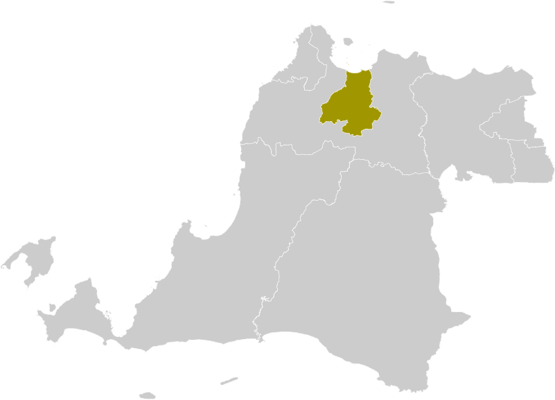
 Location in the province of Banten Location in the province of Banten
|
||
| Symbols | ||
|
||
|
Motto "Kota Serang Madani" |
||
| Basic data | ||
| Country | Indonesia | |
|
Geographical unit |
Jawa | |
| province | Banten | |
| ISO 3166-2 | ID-BT | |
| surface | 266.7 km² | |
| Residents | 643,101 (2014 estimated) | |
| density | 2,411.2 Ew. / km² | |
| founding | August 10, 2007 | |
| Website | www.serangkab.go.id ( Indonesian ) | |
| politics | ||
| Walikota ( Mayor) | Tb. Haerul Jaman | |
|
Serang Railway Station
|
||
As an independent municipality (Indonesian Kota - city), Serang is also the capital of the western Javanese province of Banten . Serang is also the administrative seat of the administrative district of the same name ( Kabupaten in Indonesian ). It takes up 5.7% of the population and 2.8% of the area of the province of Banten.
The municipality of Serang is surrounded on three sides by the reign ( Kabupaten ) of Serang and has the coast as a border ( Java Sea ) only in the north .
location
The region is predominantly flat, rising up to 648 m. The municipality is 70 km west of Jakarta and extends between 5 ° 99 'to 6 ° 22' south latitude and 106 ° 07 'to 106 ° 25' east longitude.
climate
The tropical climate brings an annual average temperature of 22 ° C (in August up to 33 ° C), there are an average of 17 rainy days (especially in January and July) and 55 millimeters of precipitation per month.
population
With 577,785 inhabitants (Census 2010), Serang was ranked 21st in the ranking of the most populous Indonesian cities. The majority of the population is of Islamic faith, the proportion of Catholics (1.1%) and Protestants (0.6%) is still lower before that of the Buddhists. Interestingly, the number of Catholics increased by 2,751 between 2012 and 2013, while the number of Protestants decreased by 5,928. The growth rate between 2012 and 2013 was 2.16%. In terms of gender, there are 105 men for 100 women. In 135,451 households (2013) the average number of people is 4.65. The population according to the continuation of the population register (DKCS 2013, indones. Ditjen Kependudukan dan Catatan Sipil ) was 565,641 in 2013.
Administrative overview of the districts
| Code / Kecamatan District |
Ibukota administrative seat |
Number of villages | Area [km²] |
population | Population density [Ew. per km²] |
|
| 2010 | 2013 | |||||
| 36.73.010 Curug | Curug | 10 | 49.60 | 47,308 | 49.181 | 992 |
| 36.73.020 Walantaka | Pipitan | 14th | 48.48 | 75,672 | 83,078 | 1,714 |
| 36.73.030 Cipocok Jaya | Cipocok Jaya | 8th | 31.54 | 80.930 | 93,081 | 2,951 |
| 36.73.040 Serang | Kaligandu | 12 | 25.88 | 208.017 | 217.504 | 8,404 |
| 36.73.050 Taktakan | Taktakan | 12 | 47.88 | 78.184 | 84.106 | 1,757 |
| 36.73.060 Kasemes | Casemates | 10 | 63.36 | 87,674 | 91,852 | 1,450 |
| 36.73 Kota Serang | 66 | 266.74 | 577.785 | 618.802 | 2,320 | |
tourism
In 2012, 148,700 guests were counted in the city's 19 hotels, 1.8% of them foreign. Of the 241,177 tourists visiting the city's objects, only 3.7% were foreigners.
history
By law No. 32/2007, the municipality ( Kota ) Serang was separated from the administrative district ( Kabupaten ).
Web links
- kotaserang.com (Indonesian)
Individual evidence
- ↑ Census (Indonesian)
- ↑ Census 2010 (Indonesian)
- ↑ Kota Serang Dalam Angka 2014 / Kota Serang in Figures 2014 (Indonesian, English)
- ↑ Government Ordinance 32/2007


