Shashe
| Shashe | ||
|
The catchment area of the Limpopo with the Shashe (upper left center) |
||
| Data | ||
| location | Border between Botswana Zimbabwe |
|
| River system | Limpopo | |
| Drain over | Limpopo → Indian Ocean | |
| source | in Botswana on the border with Zimbabwe, about 50 km west of Plumtree 20 ° 28 ′ 45 ″ S , 27 ° 21 ′ 31 ″ E |
|
| Source height | 1278 m | |
| muzzle |
Limpopo coordinates: 22 ° 11 ′ 37 " S , 29 ° 22 ′ 15" E 22 ° 11 ′ 37 " S , 29 ° 22 ′ 15" E |
|
| Mouth height | 516 m | |
| Height difference | 762 m | |
| Bottom slope | 2.1 ‰ | |
| length | 362 km | |
| Catchment area | 31,061 km² (18,991 km² in Zimbabwe and 12,070 km² in Botswana) | |
| Discharge at the Lower Shashe A Eo gauge : 7810 km² |
MNQ 1968-1999 MQ 1968-1999 Mq 1968-1999 MHQ 1968-1999 |
0 l / s 71 m³ / s 9.1 l / (s km²) 299 m³ / s |
| Outflow (712 million m³ / year) A Eo : 31,061 km² at the mouth |
MQ Mq |
22.6 m³ / s 0.7 l / (s km²) |
| Left tributaries | Tati , Ramaquabane, Santchokwe, Semokwe, Shashanti , Thuli | |
| Reservoirs flowed through | Nthimbale Dam, Shashe Dam, Dikathong Dam | |
|
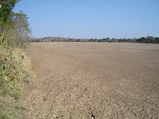
Shashe's bed |
||
The Shashe is a border river between Botswana and Zimbabwe .
course
The river has its source in Botswana, in the extreme northwest of the Limpopo catchment area, on the border with Zimbabwe, about 50 km west of Plumtree . It flows a total of about 360 km through semi-arid grazing area, of which about 100 km to the south to Shashe Dam . After the reservoir, it swings to the east and is dammed shortly before the border by the Dikathong Dam , into which its first major tributary, the Tati, flows. From 3 km after the dam, the Shashe, apart from the Tuli Circle, forms the border between Botswana and Zimbabwe. It flows into the Limpopo about 50 km from Beitbridge in the three-country corner with South Africa .
In the 1950s, this river was quite wild in the rainy season and on its banks there was only the small police station of Tuli . Today the river has been tamed and channeled into numerous irrigation systems. More and more settlements can be found on its banks. In the lowest part, the river flows through the Limpopo-Shashe Transfrontier Conservation Area , which is operated by Botswana, Zimbabwe and the Republic of South Africa .
Hydrometry
The flow rate of the Shashe was measured at the Lower Shashe station, at about 1/4 of the catchment area, in m³ / s (values read from the diagram).

Dams
In 2012, the Dikgatlhong Dam was completed on the lower reaches of the Shashe . Once it has been filled, it will form the largest reservoir in Botswana with 400 million m³.
River history
The Zambezi did not flow into the Mozambique Strait about 65 million years ago . It flowed parallel to the Cuando and Okavango and, like these, emptied into the Limpopo. The Zambezi used the river bed of the Shashe, and the Cuando that of the Motloutse .
The uplift of the Ovambo-Kalahari-Zimbabwe Fault (OKZ) created a new watershed that cut off the three rivers from the Limpopo and dammed the Makgadikgada Lake .
Web links
supporting documents
- ↑ Parameters and input data uncertainty estimation for the assessment of water resources in two sub-basins of the Limopo River Basin
- ^ A b Drought impact mitigation and prevention in the Limpopo River Basin. A situation analysis. In: Land and Water Discussion Paper. FAO Natural Resources Management and Environment Department, 2004, p. “Water Resources” , accessed April 26, 2010 .
- ^ A b Limpopo River Basin Focal Project
- ↑ Dikgatlhong Dam Project. engineeringnews.co.za, April 21, 2011, accessed July 22, 2019
- ↑ A proposed drainage evolution model for Central Africa — Did the Congo flow east?

