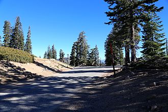
Sherman Pass (California)
| Sherman Pass (California) | |||
|---|---|---|---|
|
Sherman Pass |
|||
| Compass direction | west | east | |
| Pass height | 2804 m | ||
| region | County Tulare County , California ( USA ) | ||
| Watershed | Kern River | ||
| Valley locations | Kernville | Kennedy Meadows , Pearsonville | |
| expansion | Forest Route 22S05 | ||
| Mountains | Sierra Nevada | ||
| profile | |||
| Ø pitch | 6.62% (1627 m / 24.55 km) | 2.40% (2051 m / 85.44 km) | |
| Max. Incline | 10% | ||
| map | |||
|
|
|||
| Coordinates | 35 ° 59 '26 " N , 118 ° 21' 57" W | ||
The Sherman Pass is a 2804 m high mountain pass in the area of the Kern Plateau in the south of the Sierra Nevada in California . It is located in the sparsely populated area of the Dome Land Wilderness of the Sequoia National Forest . It represents a connection between the valleys of the headwaters of the Kern River and is crossed by the Forest Route 22S05, also known as the Sherman Pass Route.
From the top of the pass there is a view of Mount Whitney and other peaks located in Sequoia National Park in a northeastern direction .
Due to the climatic - the pass is the southernmost of the passes of the Sierra Nevada , which are usually closed between October and May - and the geographical conditions - the steep ascent from the valley of the Kern River did not allow the road to be expanded - this pass is mainly of importance for regional traffic, which only approximately 40 kilometers to the south, by the California State route 178 undeveloped Walker pass the long-distance transport is used.
In a northerly direction, the mountain range can not be crossed by motorized vehicles up to the Tioga Pass , which is around 300 kilometers to the north .

