East Pilbara Shire
| Shire of East Pilbara | |
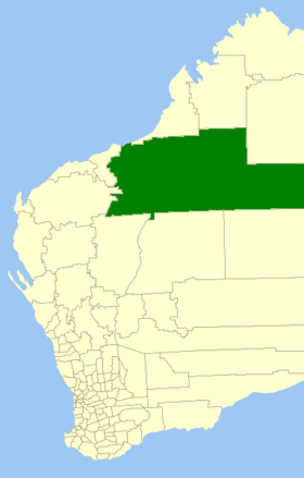
 Location of the East Pilbara Shire in Western Australia |
|
| structure | |
| State : |
|
| State : |
|
| Administrative headquarters: | Newman |
| Dates and numbers | |
| Area : | 379,571 km² |
| Residents : | 10,591 (2016) |
| Population density : | 0.03 inhabitants per km² |
| Wards : | 6th |
Coordinates: 23 ° 21 ′ S , 119 ° 44 ′ E The Shire of East Pilbara is a local government area (LGA) in the Australian state of Western Australia . At 379,571 km², it is the largest LGA in Australia. It has about 10,600 inhabitants (2016).
East Pilbara is the third largest municipality in the world after Avannaata and Sermersooq , with around 380,000 km². It's about the size of Japan .
East Pilbara is located in the north of the state about 1,000 to 1,600 kilometers northeast of the capital Perth . The seat of the Shire Council is in the city of Newman , where about 4600 inhabitants live (2016).
administration
The East Pilbara Council has eleven members elected by residents of the six wards (six from the South Ward and one each from the North, North West, East, Central and Lower Central Ward). The Council Chairman and Shire President are also recruited from among the Councilor.
Web links
Individual evidence
- ↑ Australian Bureau of Statistics : East Pilbara (S) (Local Government Area) ( English ) In: 2016 Census QuickStats . June 27, 2017. Retrieved April 13, 2020.
- ↑ Australian Bureau of Statistics : Newman (Urban Center / Locality) ( English ) In: 2016 Census QuickStats . June 27, 2017. Retrieved April 13, 2020.