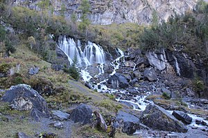
Siebenbrünnen
| Siebenbrünnen | |||
|---|---|---|---|
 Siebenbrünnen |
|||
| location | |||
| Country or region | Canton of Bern ( Switzerland ) | ||
| Coordinates | 46 ° 24 ′ 49 " N , 7 ° 29 ′ 28" E | ||
| height | 1405 m above sea level M. | ||
|
|||
| geology | |||
| Mountains | Western alps | ||
| Source type | Karst spring | ||
| Hydrology | |||
| River system | Rhine | ||
| Receiving waters | Simme → Kander → Aare → Rhine → North Sea | ||
Coordinates: 46 ° 24 ′ 49 " N , 7 ° 29 ′ 28" E ; CH1903: 604,031 / 140260
The Siebenbrünnen (also Siebenbrunnen , Siebe Brunne or Bi de Siebe Brünne ) form the source of the Simme , a river in the Bernese Oberland in Switzerland. It is a crevice from which the water emerges in seven main rays.
location
The Siebenbrünnen are located on the Rezliberg (also Räzliberg) at 1405 m above sea level. M. at the foot of the Wildstrubel . Alp Rezliberg lies on the municipality of Lenk .
geology
Siebenbrünnen is a karst spring . Karst springs are water outlet points at which the water in the mountain body flows along gaps and faults and comes from a relatively distant area. The Siebenbrünnen are fed by melt water from the Rezli Glacier. The spring discharge varies little over the course of the year due to the permanent water supply from the glacier, which is atypical for karst springs, which normally have a very variable discharge.
