Schmillenburg settlement
|
Schmillenburg settlement
City of Bergisch Gladbach
Coordinates: 50 ° 57 ′ 21 ″ N , 7 ° 7 ′ 20 ″ E
|
||
|---|---|---|
| Height : | 85 m above sea level NN | |
| Area code : | 02204 | |
|
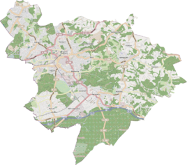
Location of the Schmillenburg settlement in Bergisch Gladbach |
||
The Schmillenburg settlement is a district in the Kippekausen district of Bergisch Gladbach .
etymology
The name goes back to the locally occurring plant species Schmielgras .
Location and description
The Schmillenburg settlement lies east of Dolmanstrasse and north of Neu-Frankenforst .
history
It was created in the early 1950s to address the acute housing shortage as a result of the confiscation of apartments by the Allied occupying powers. In addition, the city bought the site from Johann Lautz (1894–1951), after whom the local Dr.-Lautz-Weg is named. The Lautz family acquired Kippekausen in 1850.
51 houses were inaugurated on September 12, 1953.
Individual evidence
- ^ A b Andree Schulte, Bergisch Gladbach, city history in street names , published by the Bergisch Gladbach city archive, volume 3, and by the Bergisches Geschichtsverein department Rhein-Berg e. V., Volume 11, Bergisch Gladbach 1995, ISBN 3-9804448-0-5
