Lindenberg (Siegen)
| Lindenberg | ||
|---|---|---|
|
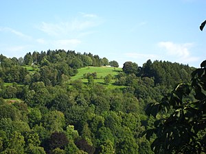
Lindenberg north side ("Katzenplätze"), seen from the Upper Castle |
||
| height | 373.4 m above sea level NHN | |
| location | North Rhine-Westphalia , Germany | |
| Mountains | Rothaar Mountains , Siegerland | |
| Coordinates | 50 ° 52 '14 " N , 8 ° 2' 27" E | |
|
|
||
The Lindenberg is 373.4 m above sea level. NN high mountain and the same area surrounding the mountain in the east of Siegen in North Rhine-Westphalia . The Lindenberg is located about one kilometer southeast of the city center on the Siegberg .
On the summit of the Lindenberg is the "Katzenplätze", a private green area that is used as a flying area by the Siegerland model sports club. There is also the district cemetery and an old Jewish cemetery on Lindenberg, as well as a crematorium since 2005 .
"Lindenberg" district

The locals refer to the northern side of the Lindenberg as a "colony". It is not a "real" part of the city's political structure, but a residential area designation in the Alt-Siegen district.
The Fludersbach industrial park also belongs to the Lindenberg district. The area is on the outskirts of Siegen and borders the Obersdorf district of the Wilnsdorf community .


