Sierra Norte de Oaxaca
| Sierra Norte de Oaxaca | |
|---|---|
| Highest peak | Cerro Pelón (Mexico) ( 3270 m ) |
| location | Southeast Mexico |
| Coordinates | 17 ° 20 ′ N , 96 ° 29 ′ W |
|
Location of the Sierra Norte de Oaxaca in southern Mexico |
|
|
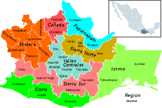
Regions in the state of Oaxaca |
|

The Sierra Norte de Oaxaca , which is sometimes over 3000 m high, forms the southeastern extension of the Sierra Madre Oriental in southern Mexico . It is also one of the 8 regions of the state of Oaxaca .
geography
The densely wooded Sierra Norte de Oaxaca is a folded mountain range and therefore of non-volcanic origin. It is approx. 70 to 90 km from the city of Oaxaca and delimits the largely mountainous state to the north from the flat foreshore of the Gulf of Mexico ; to the east joins the likewise flat isthmus of Tehuantepec . The mountain range is divided into the Sierra Juárez , the Sierra Mixe and the Sierra Mazateca .
The north side of the mountain is extremely rainy (approx. 1000 to 4000 mm / year); there are several medium-sized rivers, all of which flow north and flow into the Río Papaloapan and thus into the Gulf of Mexico. The south side, on the other hand, is rather dry and barren.
population
ethnicities
Politically, the sparsely populated mountain region of the Sierra Norte is divided into the districts of Ixtlan , Villa Alta and Mixes ; it is almost exclusively populated by people of Indian descent ( Zapotec , Mixtec , Chinanteken, Tlaxcalteken and Nahua ), who for the most part still speak their Indian languages and dialects and adhere to their - partly pre-Christian - customs.
places
In the Sierra Norte there are a total of 68 smaller communities ( municipios ) : the center of the region is the small town of Ixtlán de Juárez (approx. 3,000 inhabitants); In addition, the spa town of Capulálpam de Méndez (approx. 1,500 inhabitants) and Guelatao de Juárez (approx. 500 inhabitants), the birthplace of Benito Juárez , are of importance. The places mentioned are all at altitudes of just over 2000 m .
economy
For centuries, people lived on the yields of their maize fields (milpas) and gardens (beans, tomatoes, chilies) as self-sufficient food . Potatoes were unknown for a long time. Since the last decades of the 20th century, ecotourism (hiking, bird watching) has been added as a source of income.
history
Little is known about the history of the region. The Indian tribes living here resisted both the Aztec and Spanish occupations.
literature
- Beatriz Quintanar Hinojosa: La Sierra Norte . In: Las Rutas de México. Sur region. Guía México Desconocido 2007
Web links
- Sierra Norte de Oaxaca - Photo + Info (Spanish)

