Ixtlán de Juarez
| Ixtlán de Juarez | ||
|---|---|---|
|
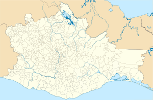
Coordinates: 17 ° 20 ′ N , 96 ° 29 ′ W Ixtlán de Juarez on the map of Oaxaca
|
||
| Basic data | ||
| Country | Mexico | |
| State | Oaxaca | |
| Municipio | Ixtlán de Juarez | |
| Residents | 2718 (2010) | |
| Detailed data | ||
| height | 2037 m | |
| Post Code | 68760 | |
| Ixtlán de Juárez - town view | ||
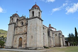
| Ixtlán de Juárez - Church of Santo Tomás Apóstol | ||
| Ixtlán de Juárez - clock tower | ||
Ixtlán de Juárez is a mountain village with approx. 3,000 inhabitants and the administrative seat of the municipality of the same name ( municipio ) with a total of approx. 8,500 inhabitants in the north of the state of Oaxaca in Mexico .
Location and climate
The place Ixtlán de Juárez is located in the up to 3270 m high mountains of the Sierra Norte approx. 66 km (driving distance) northeast of the city of Oaxaca de Juárez at an altitude of approx. 2037 m . The smaller neighboring town of Capulálpam de Méndez is only about 10 km to the south-east. The climate is temperate because of the altitude; the rain, which is abundant by Mexican standards (approx. 950 mm / year), falls mainly during the summer months.
Population development
| year | 2000 | 2005 | 2010 |
| Residents | 2,201 | 2,479 | 2,718 |
The slight but steady increase in population is mainly due to the immigration of families and individuals from the surrounding villages.
economy
The place existed before the Spanish conquest; it was founded by the Zapotec Indians. In 1775 a gold and silver mine was opened in the area; A significant part of the proceeds flowed into the organization of the church. The people of the region still live largely self-sufficient from the yields of their fields (corn, wheat) and gardens (potatoes, beans, tomatoes, chilli etc.). Cattle breeding (chickens) is only practiced to a small extent. Since the beginning of the 21st century, hiking and ecotourism have been added as a source of income for the place.
history
Little is known about the history of the place and its surroundings. The Zapotec Indians living here resisted both the Aztec and Spanish occupations.
Attractions
- Construction of the Church of Santo Tomás Apóstol began in 1640, but it was not completed until 1734. The church is very similar to the church in the neighboring town of Capulálpam de Méndez , both inside and out , but its facade design is significantly richer overall. The numerous baroque and rococo altars in the style of Churriguerism on the walls of the nave are remarkable .
- The approx. 12 m high clock tower was built at the beginning of the 20th century.
- The Museo Laayetzi presents geological and zoological exhibits. A few figure reliefs in the Zapotec style are also available.
Personalities
- Benito Juárez (1806–1872) was born in the mountain village of Guelatao, 4 km away, but was baptized in Ixtlán.
Web links
- Ixtlán de Juárez - Map + Info (INAFED, Spanish)
- Ixtlán de Juárez - Photos and information (English)


