Sigi (river)
|
Sigi Zigi |
||
|
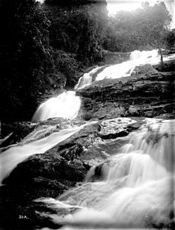
Waterfalls of the Sigi near Amani (photographed between 1906 and 1918) |
||
| Data | ||
| location |
region Tanga |
|
| River system | Sigi | |
| Source height | 1130 m | |
| muzzle | 40 km north of Tanga in the Indian Ocean Coordinates: 5 ° 2 ′ 6 " S , 39 ° 6 ′ 1" E 5 ° 2 ′ 6 " S , 39 ° 6 ′ 1" E
|
|
| length | 100 km | |
| Discharge at the Lanconi Estate A Eo gauge : 705 km² Location: 10 km above the estuary |
MNQ 1957–1990 MQ 1957–1990 Mq 1957–1990 MHQ 1957–1990 |
2 m³ / s 8 m³ / s 11.3 l / (s km²) 21 m³ / s |
| Left tributaries | Musi | |
| Right tributaries | Kihuhui | |
| Reservoirs flowed through | Mabayani Dam | |
The Sigi , in the literature often Sigifluss , ( Swahili : Mto Sigi , English : Sigi River or Zigi River ) is a river in the Tanga Region in Tanzania .
course
The river has its source in the Amani nature reserve in the Usambara Mountains , more precisely in the Handei Mountains , at an altitude of 1130 meters and, after running 100 km and changing direction several times, it flows into the Indian Ocean 40 kilometers north of the city of Tanga . Its tributaries are the Kihuhui (from the south) and the Musi (from the north). In the 1970s, the river was dammed with German financial aid (including from KfW Bank ) to create a drinking water reservoir for the region. This clay core dam, completed in 1978, was built near the village of Mabayani , hence the name Mabayani Dam ( Mabayani Dam ). The reservoir created in this way has a length of about 3,500 m, a width of about 400 m and is about 20 km from Tanga. The original capacity of 7.7 million m³ from 1978 is no longer achieved today due to erosion and landslides. In total, the river supplies around 100,000 people with drinking water , as well as tea plantations, sisal farms and industrial water .
In 1996, a Danish study found a dangerous amount of heavy metals in the water, which are released into the Sigi by the surrounding industry downstream of the reservoir.
Hydrometry
Like most rivers in the region, the Sigi flows depending on the rainy season. Average monthly flow of the Sigi measured at the hydrological station in Lanconi Estate, about 10 km above the Mabayani dam in m³ / s (1957–1990).

Individual evidence
- ^ A b Temporal Flow Variations: A Challenge for Water Management in Tanzania. Retrieved November 21, 2010 .
- ↑ Jörg Hartmann: The Tanga Model, Journal for Development and Cooperation, 2003 ( Memento of the original from December 2, 2008 in the Internet Archive ) Info: The archive link was automatically inserted and not yet checked. Please check the original and archive link according to the instructions and then remove this notice.
- ↑ a b Danish Foreign Ministry: Sustainable Tanga Program
- ↑ Hartmut F. Krebs: Review of a former student of the Dresden University of Technology (PDF; 205 kB)
- ^ IUCN Eastern Africa Program (2003): Pangani Basin: A Situation Analysis
- ↑ Eastern Arc Mountains Information Service: Protection of rain forests = Protection of watershed ( Memento of the original from February 28, 2007 in the Internet Archive ) Info: The archive link was automatically inserted and not yet checked. Please check the original and archive link according to the instructions and then remove this notice.
literature
- German Colonial Lexicon; Heinrich Schnee (ed.), Leipzig 1920; 3 volumes. Available online at Frankfurt University (entry in Vol. III, p. 357)
