Silfra column
Coordinates: 64 ° 15 ′ 17 ″ N , 21 ° 7 ′ 8 ″ W.
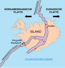
The Silfra Fissure (from Isl. Silfra 'Silver Woman') is a column-shaped , kilometer-long fault in the Icelandic Þingvellir National Park , which flows into the Þingvallavatn . The gap was created by the drifting apart of the North American and Eurasian plates . It becomes wider by around 7 mm every year. Its lowest point is 63 m below sea level.
The crevice lies in basalt rock and has a widely branched cave system on both sides. It is full of water and is fed by the meltwater from Langjökull, 50 km away . It takes about 30 to 100 years for the water to flow the 50 km route through porous lava rock. The water is also filtered through the rock.
Due to the clear water, the Silfra Fissure is a popular diving area - despite a water temperature of only 2-4 ° C. The Silfra Fissure is not only suitable for divers and snorkelers because of the lava field formations and the crystal clear water, but also because of its special location: it lies at the interface between the continental plates of America and Europe.
Individual evidence
- ↑ Thor Thordarson, Armann Hoskuldsson: "Iceland (Classic Geology in Europe 3)". Terra Publishing, Harpenden, 2007, ISBN 1-903544-06-8 , page 77
- ↑ Diving to the center of the earth


