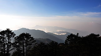
Singalila comb
| Singalila comb | |
|---|---|
|
View from Sandakphu |
|
| Highest peak | Sandakphu ( 3636 m ) |
| location | Mechi ( Nepal ), Sikkim , West Bengal ( India ) |
| part of | Himalayas |
| Coordinates | 27 ° 9 ' N , 88 ° 1' E |
The Singalila ridge ( Nepali सिङ्गलिला हिमश्रृंखला Siṅgalilā Himaśrr̥ṅkhalā , Bengali সিংগালীলা পর্বতশ্রেণী Siṅgālilā Parbataśrēṇī ) is a mountain ridge of the Himalayas along the border between Nepal and India .
The Singalila ridge runs from the Kangchenjunga Himal in a southerly direction. It forms the watershed between Tamor in the west and Tista in the east. The Mahananda drains the southern part of the mountain range together with its tributaries Kankai and Mechi . The Indian-Nepalese border runs along the ridge. India’s Singalila National Park extends over the eastern side of the mountain range.
Significant mountains of the Singalila ridge are:
The mountain ranges of Mount Everest and Kangchenjunga can be seen from the peaks of the Singalila ridge .
