Singou
| Singou | ||
|
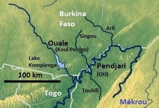
Map of the upper Oti with the Singou (middle) |
||
| Data | ||
| location |
|
|
| River system | Volta | |
| Drain over | Pendjari-Oti → Volta → Gulf of Guinea | |
| source | in Burkina Faso 11 ° 47 ′ 54 " N , 0 ° 36 ′ 15" E |
|
| muzzle | in the Pendjari coordinates: 11 ° 8 ′ 19 ″ N , 1 ° 3 ′ 13 ″ E 11 ° 8 ′ 19 ″ N , 1 ° 3 ′ 13 ″ E
|
|
| Catchment area | 5010 km² | |
|
The Singou on the border between the Réserve partial du Pama and the Arly National Park |
||
The Singou is a tributary of the Pendjari in southeastern Burkina Faso .
course
It rises in the Réserve totale du Singou and later forms the border between the Réserve partial de Pama and the Arly National Park .

