Sinni
|
Sinni Siris, Σίρις (historical) |
||
|
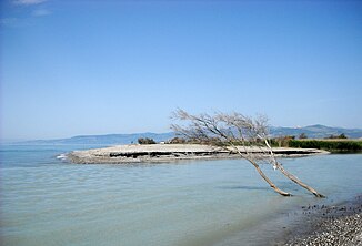
The mouth of the Sinni |
||
| Data | ||
| location | Province of Potenza , Matera | |
| River system | Sinni | |
| River basin district | Appennino Meridionale | |
| source | at Monte Sirino 40 ° 7 ′ 17 ″ N , 15 ° 51 ′ 5 ″ E |
|
| Source height | 1380 m slm | |
| south of Policoro |
Ionian Sea Coordinates: 40 ° 9 ′ 11 ″ N , 16 ° 41 ′ 30 ″ E 40 ° 9 ′ 11 ″ N , 16 ° 41 ′ 30 ″ E |
|
| Mouth height | 0 m | |
| Height difference | 1380 m | |
| Bottom slope | 15 ‰ | |
| length | 94 km | |
| Catchment area | 1292 km² | |
The Sinni (historically Siris , Σίρις ) is a river in the Basilicata region in southern Italy .
course
The Sinni rises at an altitude of 1380 m on the slopes of Monte Sirino east of Lagonegro in the province of Potenza . After a short run, it turns east, flows through the small Lago di Coliandrino and continues past Latronico and through the Lago di Monte Cotugno reservoir . Over Valsinni it flows in an arc to the Ionian Sea , into which it flows south of Policoro .
The length of the river is 94 km. Its catchment area is 1292 km².
Tributaries
From the right the Torrente Frido , the Torrente Ruppio and the Torrente Lappio flow to the Sinni , from the left the Torrente Serrapotamo , the Canale Riposo and the Canale Pescogrosso .
Web links
Commons : Sinni River - collection of images, videos and audio files
Individual evidence
- ^ FW Putzger: Historical World Atlas, 92nd edition - anniversary edition, Berlin and Bielefeld: Velhagen & Klasing, map 22

