
Basilicata
| Basilicata | |
|---|---|
  |
  |
| Basic data | |
| Capital | Potenza |
| Provinces | Potenza , Matera |
| surface | 9,994.61 km² ( 14. ) |
| Residents | 556,934 (Dec. 31, 2019) |
| Population density | 55.7 inhabitants / km² |
| Website | Basilicata |
| ISO 3166-2 | IT-77 |
| president | Vito Bardi ( FI ) |
 Relief map of the Basilicata region |
|
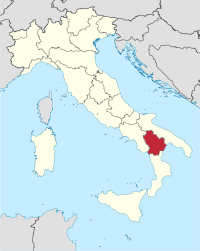
Basilicata ( Italian Basilicata ) is a region in southern Italy . It is located southeast of Campania , southwest of Apulia and north of Calabria . It is divided into the provinces of Potenza and Matera , with a total of 556,934 inhabitants (as of December 31, 2019) living on an area of 9,994 km². The capital is Potenza . The province of Potenza , which lies around the capital, was called the province of Basilicata before 1871 , but was only part of the present-day region of Basilicata.
Administrative division
The Basilicata region includes the following two provinces:
| province | Capital | ISO | Communities | Population (December 31, 2019) |
Area (km²) | Population density (inh / km²) |
|---|---|---|---|---|---|---|
| Matera | Matera | IT-MT | 31 | 195.998 | 3,446.12 | 57 |
| Potenza | Potenza | IT-PZ | 100 | 360.936 | 6,548.49 | 55 |
| Basilicata | Potenza | IT-77 | 131 | 556.934 | 9,994.61 | 56 |

Major cities and towns
The following are the largest cities and municipalities in Basilicata:
| local community | province | Residents |
|---|---|---|
| Potenza | Potenza | 67.194 |
| Matera | Matera | 60,432 |
| Melfi | Potenza | 17,885 |
| Policoro | Matera | 17,709 |
| Pisticci | Matera | 17.605 |
| Lavello | Potenza | 13,424 |
| Rionero in Vulture | Potenza | 13,214 |
| Lauria | Potenza | 12,708 |
| Bernalda | Matera | 12,451 |
| Venosa | Potenza | 11,741 |
coat of arms
Four blue wavy bars the width of a thread in the middle of the silver shield .
Demarcation Basilicata / Lucania
The territory of Basilicata only partially coincides with the ancient landscape of Lucania . It has only a narrow part of the Tyrrhenian coast, while Lucania extended far into what is now the Campania region and encompassed most of the current province of Salerno , in particular the Cilento landscape , up to the Sele River (Latin: Silarus). On the other hand, Lucania reached northeast only as far as the Bradano river ; the Basilicata also extends in a north-westerly direction beyond the borders of Lucania, where it includes the Vulture area - the area of origin of the Aglianico del Vulture wine .
The name "Basilicata" appeared in the 10th century under Byzantine rule. After the Norman conquest of southern Italy , an administrative unit (giudizierato) that comprised what is now the province of Potenza and part of the province of Matera bore this name.
history
The area has never been independent since its incorporation into the Roman Empire and shared the history of its neighboring areas (for the period between the Lombard (568) and the Norman conquests, in which southern Italy was territorially fragmented, this applies primarily to the northern neighboring areas). After the Norman conquest, it belonged to the Kingdom of Naples , and from 1861 to Italy. From 1932 to 1947 the region was officially called "Lucania".
climate
Compared to the rest of southern Italy, Basilicata has a very changeable climate. In winter the temperatures are usually between 5 ° C and 9 ° C. During the summer months, temperatures are around 28 ° C to 31 ° C. With an average of 12.9 ° C, the climate in this region is milder than in the rest of the country. Due to the sometimes high amounts of precipitation between November and April, there are good climatic conditions for viticulture . Therefore, various grape varieties have been bred in parts of this region since the 6th century BC.
economy
In comparison with the GDP of the European Union expressed in purchasing power standards , the Basilicata region achieved an index of 71 in 2015 (EU-28 = 100).
In 2017 the unemployment rate was 12.8%, which was the lowest rate in southern Italy.
photos


Magazines
- Bollettino della storia della Basilicata , has been published since 1985
literature
General
- Michael Mente: Matera, the Basilicata and me. A personal and literary travel companion in search of the mystical heart of southern Italy. Edited by von flügelrad, Verlag für Kulturvermittlung, BoD Books on Demand, Weinfelden 2019, ISBN 978-3-7494-5245-3 .
geography
- Carlos Solito: Basilicata. Parco nazionale del Pollino , Edizioni Pugliesi, 2004.
history
- Gabriele De Rosa, Antonio Cestaro, Dinu Adamesteanu (eds.): Storia della Basilicata , 4 vols., Laterza, Bari 1999-2006.
- Palma Fuccella: Breve storia della Basilicata , Finiguerra Arti Grafiche, 1996.
- Edoardo D'Angelo: Basilicata medievale. La cultura , Liguori, 2009.
- Pierfrancesco Rescio: Archeologia e storia dei castelli di Basilicata e Puglia , Consiglio regional di Basilicata, 1999.
- Vittorio Prinzi, Tommaso Russo: La massoneria in Basilicata. Dal decennio francese all'avvento del fascismo: Dal decennio francese all'avvento del fascismo , FrancoAngeli, Milan 2012.
- Tommaso Russo: Culture e scuole in Basilicata nell'Ottocento , FrancoAngeli, 1995.
- Tommaso Russo: Istruzione e sociabilità in Basilicata, 1900–1921 , FrancoAngeli, 2004.
art
- Klaus-Rainer Althaus : The apse paintings of the cave churches in Apulia and in Basilicata. Iconographic research . Hamburg 1997, ISBN 3-86064-539-0
- Ekkehart Rotter: Calabria, Basilicata . DuMont Art Travel Guide, Ostfildern 2002, ISBN 3-7701-5541-6
Web links
Individual evidence
- ↑ Statistiche demografiche ISTAT. Monthly population statistics of the Istituto Nazionale di Statistica , as of December 31 of 2019.
- ↑ See the articles Duchy of Benevento , Arabian Conquest of Southern Italy and Principality of Salerno .
- ↑ Climate in Basilicata. Retrieved August 8, 2018 .
- ↑ Eurostat. Retrieved August 22, 2018 .
- ↑ Unemployment rate, by NUTS 2 regions. Retrieved November 5, 2018 .
Abruzzo | Aosta Valley | Apulia | Basilicata | Emilia-Romagna | Friuli Venezia Giulia | Calabria | Campania | Lazio | Liguria | Lombardy | Brands | Molise | Piedmont | Sardinia | Sicily | Tuscany | Trentino-South Tyrol | Umbria | Veneto
Coordinates: 40 ° 31 ' N , 16 ° 6' E