
Sitzenrodaer Bach
|
Sitzenrodaer Bach Dorfbach, Neumühl (en) bach |
||
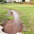
 Dam in the Sitzenrodaer Bach in Sitzenroda |
||
| Data | ||
| location | Nordsachsen , Saxony , Germany | |
| River system | Elbe | |
| Drain over | Heidebach → Schwarzer Graben → Elbe → North Sea | |
| Source height | approx. 167 m | |
| muzzle | south of Klitzschen in den Heidebach Coordinates: 51 ° 30 '34 " N , 12 ° 53' 57" E 51 ° 30 '34 " N , 12 ° 53' 57" E |
|
| Mouth height | approx. 89 m above sea level NN | |
| Height difference | approx. 78 m | |
| Bottom slope | approx. 6.3 ‰ | |
| length | about 12.4 km | |
The Sitzenrodaer Bach , sometimes also called Neumühlbach or simply Dorfbach , is a 12.4 kilometer long right tributary of the Heidebach in the district of Northern Saxony in Germany.
geography
The Sitzenrodaer Bach rises between the villages of Sitzenroda and Schmannewitz in the Dahlener Heide in the Sieben-Quellen-Tal . In the eponymous village of Sitzenroda, it runs between the S 24 and the neighboring road to the source valley . Further down the stream it touches the Neumühlteich , flows past the Blankenau estate and the Mockrehna district of Langenreichenbach . A little south of Klitzschen it flows into the Heidebach, which flows a good 900 meters further into the Schwarzen Graben .
Picture gallery

Bridge over the upper reaches of the Sitzenrodaer Bach in Sitzenroda with low discharge
Bridge over the upper reaches of the Sitzenrodaer Bach in Sitzenroda with low discharge

