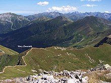
Siwy Zwornik
| Siwy Zwornik | ||
|---|---|---|
|
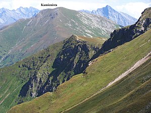
Below the Kamienista |
||
| height | 1965 m npm | |
| location | Poland / Slovakia | |
| Mountains | Western Tatras , Carpathian Mountains | |
| Coordinates | 49 ° 12 '7 " N , 19 ° 49' 51" E | |
|
|
||

From the Ornak
The Siwy Zwornik is a mountain on the Polish-Slovakian border in the Western Tatras with an altitude of 1965 meters.
Location and surroundings
The state border runs over the main ridge of the Tatra Mountains , on which the Siwy Zwornik is located. North of the summit lie the Chochołowska valley , specifically its Dolina Starorobociańska hanging valley , and the Kościeliska valley , specifically its Dolina Pyszniańska hanging valley .
tourism
The Siwy Zwornik is popular with hikers.
Routes to the summit
The hiking trail to Siwy Zwornik leads along the main Tatra ridge and the Polish-Slovak border.
- ▬ A red marked hiking trail leads from Wołowiec over the summit to the Liliowy Karb mountain pass.
- ▬ A green hiking trail leads from the Iwaniacka Przełęcz mountain passover the Ornak to the summit
The Ornak Hut and the Chochołowska Hut are ideal starting points for an ascent from the valleys .
Web links
Commons : Siwy Zwornik - collection of pictures, videos and audio files
supporting documents
- Zofia Radwańska-Paryska, Witold Henryk Paryski, Wielka encyklopedia tatrzańska, Poronin, Wyd. Górskie, 2004, ISBN 83-7104-009-1 .
- Tatry Wysokie słowackie i polskie. Mapa turystyczna 1: 25.000, Warszawa, 2005/06, Polkart, ISBN 83-87873-26-8 .

