Slotø
| Slotø | ||
|---|---|---|
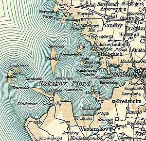
| Nakskovfjord with Slotø on a map from around 1900 | ||
| Waters | Baltic Sea | |
| Archipelago | Great Belt | |
| Geographical location | 54 ° 50 '25 " N , 11 ° 3' 30" E | |
|
|
||
| surface | 19.1 ha | |
| Highest elevation | 1 m | |
| Residents | uninhabited | |
Slotø is a Danish island in the Nakskovfjord , a side bay of the Great Belt on the west coast of the island of Lolland, which has been uninhabited since the late 1960s . The island is 19.1 hectares and its highest point is two meters above sea level. The ruins of Engelsborg Castle are located on the northern tip of the island .
Slotø belongs to the parish ( Danish : Sogn ) Sandby ( Sandby Sogn ), which belonged to Harde Lollands Nørre Herred in what was then Maribo Office until 1970 . From 1970 it belonged to the Ravnsborg municipality in what was then Storstrøms Amt , which was merged into the Lolland municipality in the Sjælland region with the municipal reform on January 1, 2007 .
Individual evidence
- ↑ Statistics banks -> Befolkning og valg -> BEF4: Folketal pr. January 1st demands på øer (Danish)
- ↑ Danmarks Statistics : Statistisk Aarbog 1920 - Table 3: Arealets Fordeling paa de forskellige større og minre Landsdele including Folkemængde og Befolkningstæthed on February 1, 1916, footnote 6 (Danish / French; PDF; 1.1 MB)

