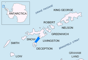
Smolensk Strait
| Smolensk Strait | |
|---|---|
| Connects waters | Bransfield Street |
| with water | Bransfield Street |
| Separates land mass | Livingston Island |
| of land mass | Deception Island |
| Data | |
| Geographical location | 62 ° 50 ′ S , 60 ° 26 ′ W |
| Smallest width | 18.4 km |
The Smolensk Strait ( Bulgarian проток Смоленск protok Smolensk ) is a 18.4 km wide strait in the archipelago of the South Shetland Islands . It lies between Macaroni Point at the northeastern end of Deception Island and Barnard Point on the Roschen Peninsula of Livingston Island .
British scientists mapped them in 1968, Spanish ones in 1991. The Bulgarian Commission for Antarctic Geographical Names named them in 2012. The reason for the naming is that the Russian navigator Fabian Gottlieb von Bellingshausen and the American sealer captain Nathaniel Palmer met here on February 6, 1821 and the former named Livingston Island in memory of the Battle of Smolensk in 1812.
Web links
- Smolensk Strait in the Composite Gazetteer of Antarctica (English)
