Solla (Thurmansbang)
|
Solla
Thurmansbang parish
Coordinates: 48 ° 48 ′ 40 ″ N , 13 ° 18 ′ 1 ″ E
|
||
|---|---|---|
| Incorporation : | January 1, 1972 | |
|
Location of Solla in Bavaria |
||
|
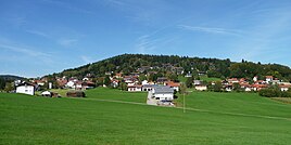
View of Solla
|
||
Solla is a district of Thurmansbang in the Lower Bavarian district of Freyung-Grafenau . Until 1972 Solla formed an independent municipality.
location
Solla is located in the Bavarian Forest five kilometers northwest of Thurmansbang on the edge of the Sun Forest at an altitude of about 700 meters on the southeast slope of the mountain Windhoch.
history
In 1152 Salha (sal = willow) was first mentioned in a document from Osterhofen Monastery . Richardis (Richkardis), the widow of the knight Rudolf von Scharten, left her considerable property near Salha and the surrounding area to the monastery in order to secure a burial place there.
In the Halser Salbuch from 1395, six estates are listed in Salach . In 1700, Sollach was called the Hofmark Zenting landable. It was not until August 10, 1808, in the house and rustic tax cadastre of the Schönberg Regional Court and Rent Office , that the place was referred to as both Sola and Solla . In the original map of Solla 1827 a total of five properties are listed. In 1850 the village burned down.
In 1953 the school camp was opened. On January 1, 1972, the municipality of Solla joined Thurmansbang as part of the regional reform in Bavaria . Solla also had its own school, which was closed as part of the rural school reform.
Special features and sights
- Solla holiday village. The holiday village located on a south-west slope offers two different types of holiday homes with a size of 70 m² and 45 m². All houses are equipped with a living room, one or two bedrooms, hallway, bathroom, balcony or terrace.
- Elephant meeting . The elephant meeting, the world's oldest and largest winter meeting for motorcyclists, takes place every year near Solla near the small town of Loh, which is also known for the rocking rock of Loh.
- Stock car racing track. The race track in Solla belongs to the SCC Solla. The track lies in the bottom of a valley, which gives the audience an overview of the entire track.
- Schartenkirchlein St. Michael. It is located about 750 meters southwest of Solla on a hill where the castle of the noble von Scharten once stood. The originally Romanesque church was possibly the castle chapel. In 1597, Abbot Michael Vögele from Osterhofen Monastery gave it a Gothic choir vault, and the tower was moved to the west side. The crucifixion group is also Gothic.
- Wacholderheide landscape protection area. At the Schartenkirchlein is the 55-hectare landscape protection area, which has existed since 1960 and which takes its name from the juniper stocks that occur here .
- Lookout high wind
societies
- Windhochschützen Solla eV, founded in 1979, registered in 1981
- Solla Volunteer Fire Brigade, founded in 1885
- Women's regulars table Solla
- Men's regulars table Solla
- Soldiers and reservists association Solla
- Motorcycle friends Solla
- StockCarClub Grünthal eV (Stock Car Club Solla eV), founded in 1977, registered in 1978
- Curling Club Solla
- Huntsmen Solla
literature
- Hermann Neumann: History of the Grafenauer Land , in: The district of Freyung-Grafenau , Freyung 1982, ISBN 3-87553-1922

