
Soufrière (Guadeloupe)
| La Soufriere | ||
|---|---|---|
 Soufriere |
||
| height | 1467 m | |
| location | Guadeloupe ( Caribbean ) | |
| Coordinates | 16 ° 2 '35 " N , 61 ° 39' 49" W | |
|
||
| Type | Stratovolcano , active | |
| Age of the rock | over 200,000 years | |
| Last eruption | 1976 | |

The Soufrière (or La Soufrière ) is an active volcano on Basse-Terre , one of the two main islands of the French overseas department of Guadeloupe in the Caribbean . At 1,467 m , La Soufrière is the highest mountain in the Lesser Antilles . He is the center of the built of volcanic rock massif Grand Découverte-Soufrière and is located in the 17,300 ha large national park on the island .
Based on rock surveys, the last major magma eruption was dated to around 1440 AD. In the period after Guadeloupe was settled by Europeans, the Soufrière was active several times. In 1797/98, 1836/37, 1956 and between June 1975 and March 1977 there were some long-lasting activities. The last eruption, a phreatic eruption , led to a four-month evacuation of the community of Basse-Terre , located at the foot of the volcano, including a relocation of the administration and a total of 60,000 inhabitants. There was a dispute among scientists (including Claude Allègre and Haroun Tazieff ) about the actual danger emanating from the Soufrière and the need for an evacuation. In the end, the outbreak did not cause any significant damage or claim any human lives. During the time of the evacuation, the filmmaker Werner Herzog traveled to the capital, Basse-Terre. He captured his impressions in the film La Soufrière - Waiting for an Inevitable Disaster .
The volcanic and seismic activities of the Soufrière have been extensively monitored since 1950. Since the observation center in Saint-Claude at that time had to be evacuated in 1976, it was moved to Fort Saint-Charles . Since 1989 there has been a modern observation center ( L'Observatoire volcanologique et sismologique de Guadeloupe ) on Houëlmont, 9 kilometers from the Soufrière volcanic cone, in the municipality of Gourbeyre .
The volcanic cone rises about 300 meters above the plateau called Savane à Mulets . The cone has a diameter of about 900 meters at its base and a diameter of 400 meters at the top. The cone is the only naturally forest-free zone on Basse-Terre. On the south crater, sulfur fumes from solfataras are constantly emerging from two volcanic gullies ( Gouffre Tarissan and Gouffre Dupuy ) .

Soufrière volcanic cone

View to the Gouffre Tarissan throat
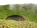
The crater lake Lac Flamarian on the Citerne


Web links
- La Soufrière geology, the 1976-1977 crisis and evacuation
- Soufrière (Guadeloupe) in the Global Volcanism Program of the Smithsonian Institution (English)