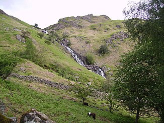
Sour Milk Gill (Easdale Beck)
| Sour Milk Gill | ||
|
The Sourmilk Gill |
||
| Data | ||
| location | Cumbria , England | |
| River system | Leven | |
| Drain over | River Rothay → Leven (Cumbria) | |
| River basin district | North West | |
| origin | Outflow of the Easedale Tarn 54 ° 28 ′ 11 ″ N , 3 ° 3 ′ 56 ″ W. |
|
| Source height | 282 m ASL | |
| muzzle | in the River Rothay Coordinates: 54 ° 28 ′ 7 " N , 3 ° 2 ′ 55" W 54 ° 28 ′ 7 " N , 3 ° 2 ′ 55" W |
|
| Mouth height | 100 m ASL | |
| Height difference | 182 m | |
The Sour Milk Gill is a small river in the Lake District , Cumbria , England . The Sourmilk Gill arises as a drain of the Easedale Tarn and flows in an easterly direction. When he met the Far Easedale Gill , the Easedale Beck was created .
